It had been almost a year since I last visited the Slaughter Pen in Bentonville, AR, and I had been dying to go back! I had seen so many videos of new and improved trails that looked like tons of fun! Plus, I’m on a more capable bike now, and my skills have improved quite a bit since last summer.
The Slaughter Pen is a unique trail system, right in the heart of Bentonville. It’s a series of short trails that are all connected by a paved greenway. This is a super nice area, and each visit I saw numerous folks out and about, whether they were running, biking, or just out for a walk. There’s everything from beginner trails, to advanced, as well as a pump track and skills area.
Schroen Train was probably my favorite trail, but there is a lot of good stuff out there! Ozone is a new trail, and it was very fast, flowy, and fun as well! I ended up logging about 15 miles that morning. If you haven’t been to the Slaughter Pen or Bentonville, I’d highly recommend it!
After the ride (and a shower) I stopped and had lunch at a fantastic little place called MELD Kitchen + Sandwich Bar. I had the “Catch” which is a folded sandwich with grouper, and it was sooooo goooood!
After spending the afternoon relaxing in my hotel room, I headed back out for sunset to get some drone shots, as well as a couple photos, at nearby Beaver Lake. Nothing too fancy here.
That’s a pretty solid day, I’d say! Here is the video!
This past weekend I headed up north from Dallas to my favorite weekend getaway destination for mountain biking, Bentonville, AR! It’s getting to the point, however, where you just have to say Northwest Arkansas, because there are so many trails all over the place, with more new trails opening all the time, that Bentonville isn’t the only city worth a visit!
Just 20 minutes to the south in the city of Springdale, a brand new trail system had just opened up at Fitzgerald Mountain. 7 miles are currently open, with another 3 miles to be opened in the fall. As of right now, you park at Bayyari Park to access the trail, but they will be building a new trailhead and parking lot as well, I believe off Dodd Ave.
These trails were so much fun! There are many undulations that can be pumped to gain or maintain speed, or even get some air, as well as bigger jumps, gap jumps (that I skipped!), and so many berms! The rock work is like art, including a couple of rock berms that are unlike anything I’ve ever seen!
Here’s a list of the individual trails, their difficulty rating, and a short description:
1. Butterfield Trail – Blue – 2.4 miles – I’d describe it as a flow trail, with some jumps, berms, and a few rock features.
2. Best Trail Ever – Black – 3.0 miles – The name says it all! This trail is fantastic, with some beautiful rock work, including some technical sections, jumps, berms, and some good speed! It’s a blast!
3. Fitzgerald – Blue – 0.6 miles – A shorter loop, with very little elevation change, and more natural trail.
4. 1857 – Black – 0.1 miles – This is an alternate route off of Fitzgerald for those looking for some technical challenges. Lots of rocks to navigate here. I did not ride this trail, but got a good look at it.
5. Coyote Cave – Black – 0.6 miles – Best ridden from north to south so that it’s mostly downhill, this trail features more fantastic rock work, a small cave, more flowy berms, several jumps, and a big gap jump near the bottom.
Here’s how I’d ride it:
Starting at the trail head at Bayyari Park, go north on Butterfield. The first intersection you’ll come to will be with Coyote Cave. Save it for the way back. Next you’ll reach a split in Butterfield. Go right to take you to the hub of all the other trails (you’ll have to return to ride this section again later in order to cover all trails). You’ll climb up and reach another split, where you should stay right. This will take you to the center hub, where the trail circles around a tree in the middle, and the other trails branch off of this circle.
Go around to Fitzgerald. You’ll have two options, take the one on the left. Shortly after heading down Fitzgerald you’ll have the option of adding 1857 (on your left). Pick back up on Fitzgerald until you come to the entrance to Best Trail Ever on the left. Take it and head right (counter-clockwise). You’ll come back to this intersection and continue on Fitzgerald to the left, taking you back to the central hub.
From the hub, go back down Butterfield, and head right at the intersection. This will take you around the loop, allowing you to enjoy mostly downhill. You’ll meet up with the intersection you were at during the early stages of the ride, and take the same trail (to your left this time) that heads back up to the central hub.
Once you’re back at the hub, you can start your run down Coyote Cave. When that meets back up with Butterfield, head back south to the trailhead.
Okay, let’s get caught up here! Sorry, I have a tough time keeping up with writing blogs! Much more exciting to put together videos!
After the quick stop in Fruita to ride Horsethief Bench, I continued on to Moab! I came for Outerbike. Originally I was going to try out bikes that I was interested in buying, but since I got my YT Jeffsy back in December (25% off, couldn’t pass it up), I was just trying out bikes for fun!
Before all of that, I went on a hike to see an arch that I didn’t get to see on my first trip to Moab; Corona Arch. This is outside of the National Park, but in my opinion is just as good, if not better, than anything in the park!
The goal was to get a good sunset, but when I started the hike, the sky was filled with clouds. A lot of people were returning from the arch, and by the time I was actually standing underneath it, I was the only one there! Not only that, but the clouds broke just enough to let the sun shine through and provide some brilliant light for some incredible photos!
I hiked back in the dark a very happy man!
Day 1 of Outerbike took me to the Navajo Rocks loop on the Yeti SB5+. I only rode half of the loop to try to save some energy for the rest of the weekend. It was a fun trail, with nothing too difficult. A good warmup in Moab! After returning to the Bar M trails where the event was located, I picked up an Ibis Mojo HD4 and hit a trail I had on my list: Sidewinder. Unlike any other trail in Moab, this one is almost completely smooth, and full of flow & speed! It was so much fun!
Day 2 was Mag 7 on the Giant Trance Advanced 2! All of it! Prior to this trip I had reached out to another YouTuber from Grand Junction, R.C. of Outdoor Gold. I was actually looking to meet up with him to ride Horsethief Bench, but as it turned out he had planned a group ride at Mag 7 on the same day Outerbike took me there. Admittedly, I didn’t communicate well on meeting up, but as luck would have it, I saw him and his group just heading out as the shuttle arrived at the trailhead. I was able to catch up with them for the start of the most epic day ever on the bike! My left calf cramped twice, I hit drops and other technical features unlike anything I had ever done before, I ran out of water, I walked… a lot… but it was SO MUCH FUN! Luckily these guys offered to take me back to Outerbike, otherwise I would have had to cut the ride short and miss out on Gold Bar Rim & Portal… which was THE trail I really wanted to ride on the Mag 7! With extreme exposure on the edge of a cliff, Portal is not for the faint of heart! Riders have fallen to their death on this trail, and there are signs along the way warning everyone of just that. There were several spots where we all got off the bikes and walked, and there is no shame in that!
Day 3 of Outerbike took us to Captain Ahab, and I was riding an Evil The Calling. This was another trail that I was super excited about, and after tackling a couple double black diamonds the day before, I was feeling very confident. Um… maybe a bit TOO confident! I ended up crashing twice, and one of those crashes left me with a broken wrist! It was one of the carpal bones, the trapezium. A small 5mm fracture, and initially I didn’t even know it. I finished the ride, and in fact bossed the most rowdy section of the whole trail with my wrist already broken! It honestly didn’t hurt that much for the remainder of that ride, but afterward I was feeling it!
I had originally planned on riding Slickrock the following day, but with my hand in so much pain, I skipped it and just toured the La Sal Mountain Loop Road, and flew the drone.
It wasn’t actually until 2 weeks later that I found out my trapezium had a fracture! Since then, I’ve been in a cast for 4 weeks, a brace for another 2, and the fracture didn’t even heal! It is a nonunion, and apparently there is no solution from here. I just get to have a little bone fragment chillin in my wrist for the rest of my life! I still have some pain, mainly around the thumb, which is from it being stuck in that cast for a month. The area of the fracture isn’t tender to the touch, and the pain that I was feeling with lifting objects with my palm facing up has gone away. Nonetheless, I’m having to ease back into mountain biking, as all of the muscles surrounding the thumb, and the PIP joint of the thumb, will hurt moderately bad during and immediately after riding.
Anyway, check out the whole series of videos from this trip here:
The place I was staying in Moab for Outerbike didn’t have any rooms available on the first night that I had planned to be there, so I stayed in Grand Junction, CO instead, which gave me the opportunity to ride the very popular Horsethief Bench trail in Fruita, CO!
I’ve seen quite a few videos of this trail, so I had a good idea of what to expect. The beginning is a super difficult “drop in” which trail guides actually call a hike-a-bike section, but advanced riders are able to ride the whole thing. What you see on video versus what you see in person, however, are vastly different!
The biggest thing to me that video failed to portray is just how steep the whole thing is. It wouldn’t take much of a stop of your front tire to send you over the bars!
The rest of the trail was a blast, and there was only one short section that I skipped, being that I was riding alone, and it was a weekday, meaning the trail was pretty empty.
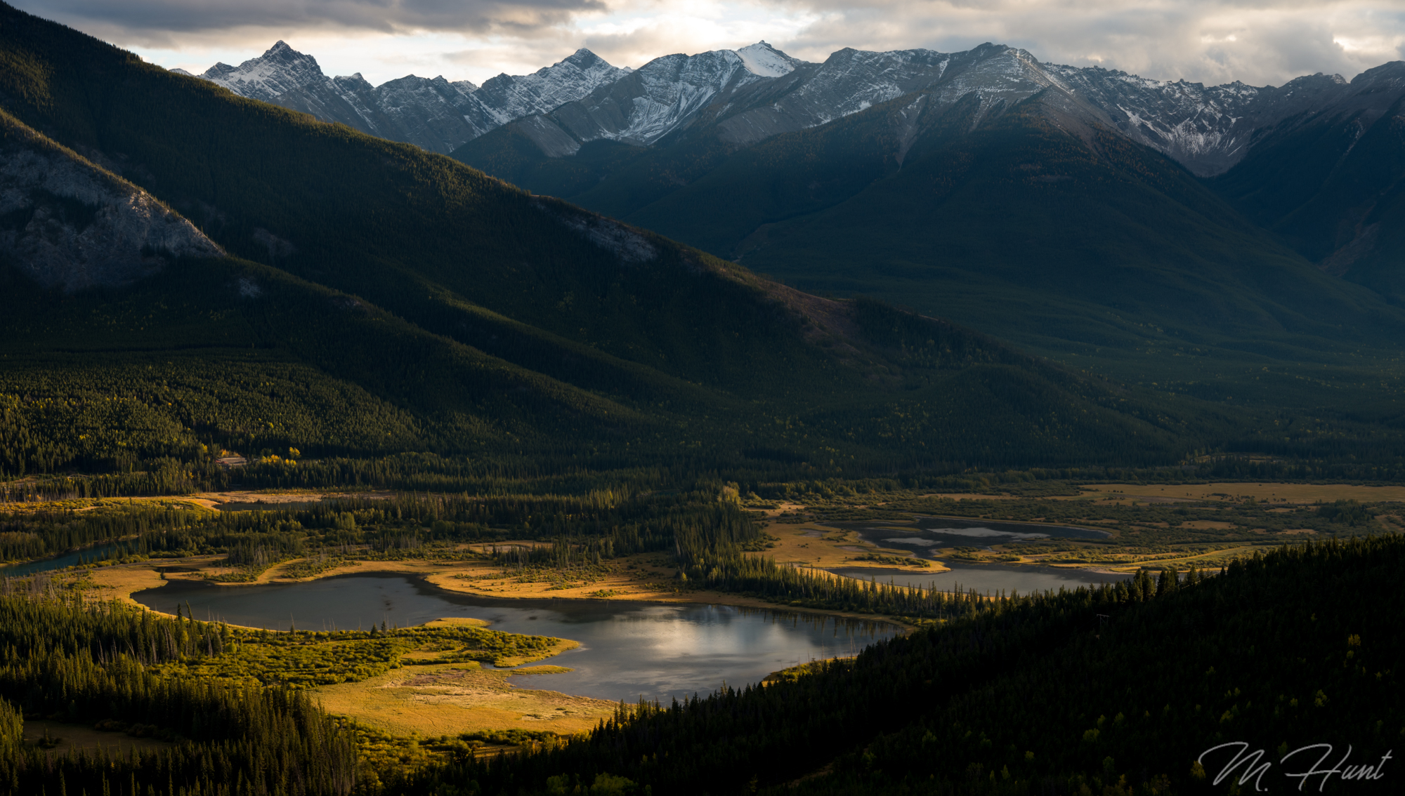
One evening of my fall Canada vacation I decided to drive up to the Norquay Ski Area to take some photos at sunset. Little did I know what I was in store for!
There were a lot of clouds at the time, but the breaks in the clouds allowed rays of sunlight to shine through, creating a very dramatic scene in the valley over the Vermillion Lakes. I was so excited I was literally pumping my fist, smiling from ear-to-ear, and yelling, “YES!” I honestly don’t think I’ve ever gotten so pumped up about the photos I was taking! I feel like this looks like something out of a movie! What do you think?
A couple weeks ago I took a crazy trip to Big Bend! Why was it crazy, you ask? Because Big Bend is a 9 hour drive, and I did it on a normal weekend.
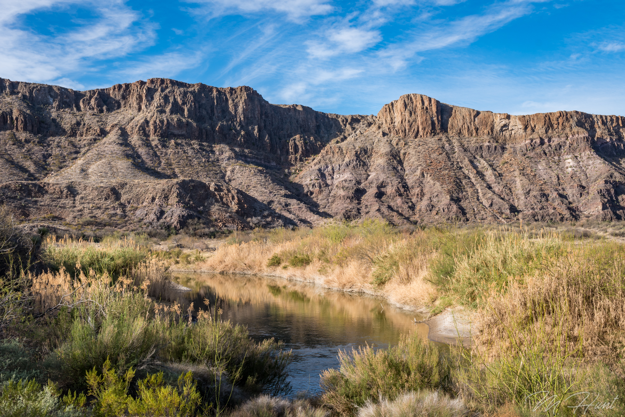
I left work at 5 pm on Friday evening, and after fighting the DFW traffic & rain (which makes traffic about 8 gazillion times worse) I arrived in Terlingua at around 2:15 am. I “slept” in my car at a free campsite, waking before the sunrise.
I went out from there to take some photos and video, and then went mountain biking on the Dome Loop in Big Bend Ranch State Park.
I met some great people in the parking lot of the visitor’s center, Danny & Darlene, and went biking with Danny, then hung out with them afterward in their Sprinter camper van. They have been traveling the country while living in the van for the past 11 months! I’m jealous!
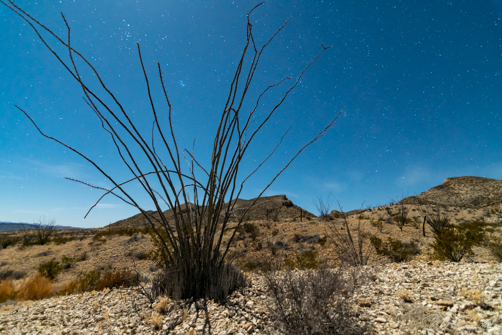
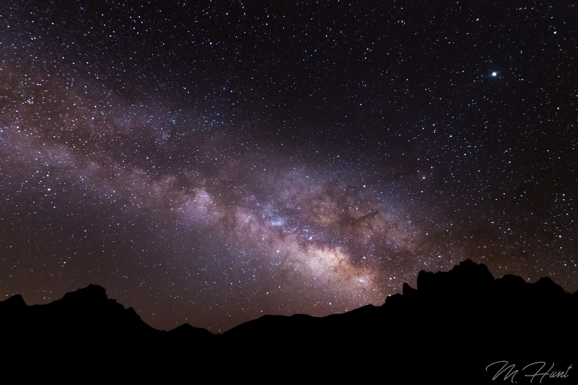
That night I stayed at a legit campsite, which was amazing, and the moonlight lit up everything!
After a much better (but chilly) night of sleep, I rose super early to make a 45 minute drive to Big Bend National Park to shoot the Milky Way.
Sunday morning was the Lajitas Airport trails, and then the 9 hour drive back home!
Don’t let a lack of money or lack of time keep you from traveling. This trip cost roughly $100 (gas + $10 for the campsite) and didn’t require any PTO time. Yes, I spent 18 hours of my weekend driving, and far less than that sleeping, but you only get one life, so CARPE DIEM! The memories are worth far more than the time and the money spent.
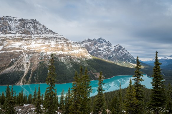
Oh Peyto Lake, how beautiful you are! Yes, the color of the water is real! It’s caused by the glaciers scraping tiny particles of the limestone, thus suspending these particles, known as rock flour, in the water. That is how it gets that unique turquoise color.
You’ll notice something else at Bow Summit. It’s at a higher elevation than Lake Louise to the south, so temperatures are much cooler, and it’s more likely you’ll run into ice & snow, as I did in late September.
It was mostly cloudy at this point in the morning, but a brief break in the clouds revealed a spotlight onto the mountains for the perfect shot!
“We yell on the trail, because the bears come close.”
That’s what the woman at the bike shop told me when I checked out my rental bike at the Canmore Nordic Centre. By the way, we’re talking about grizzly bears, not black bears! A bit nerve wracking, but certainly not enough to stop me from riding! Besides, I had bear spray with me. 😉
I screwed up by not ensuring that my gimbal batteries were fully charged, nor did I bring the spares with me, and the result was a gimbal that didn’t work as well as it could have. That was disappointing to me when I watched the footage back, because the riding was outstanding! The dirt was amazing. I know that sounds weird to anyone who is not a mountain biker. Let me try to explain. It wasn’t mud, but there was enough moisture to keep it soft, and prevent loose dirt from laying on top of the hard-packed trail. This is what we call “hero dirt” because you can go ahead and be a hero riding it! It has a high amount of grip, but it’s not tacky like mud. You can get a lot of speed.
Even without the great dirt, the trails were well designed, and being in that pine forest is what dreams are made of! Although I was somewhat adjusted to the elevation at this point, my legs were still sore from hiking two days prior, and the amount of climbing I did on this ride wore me out after 13+ miles.
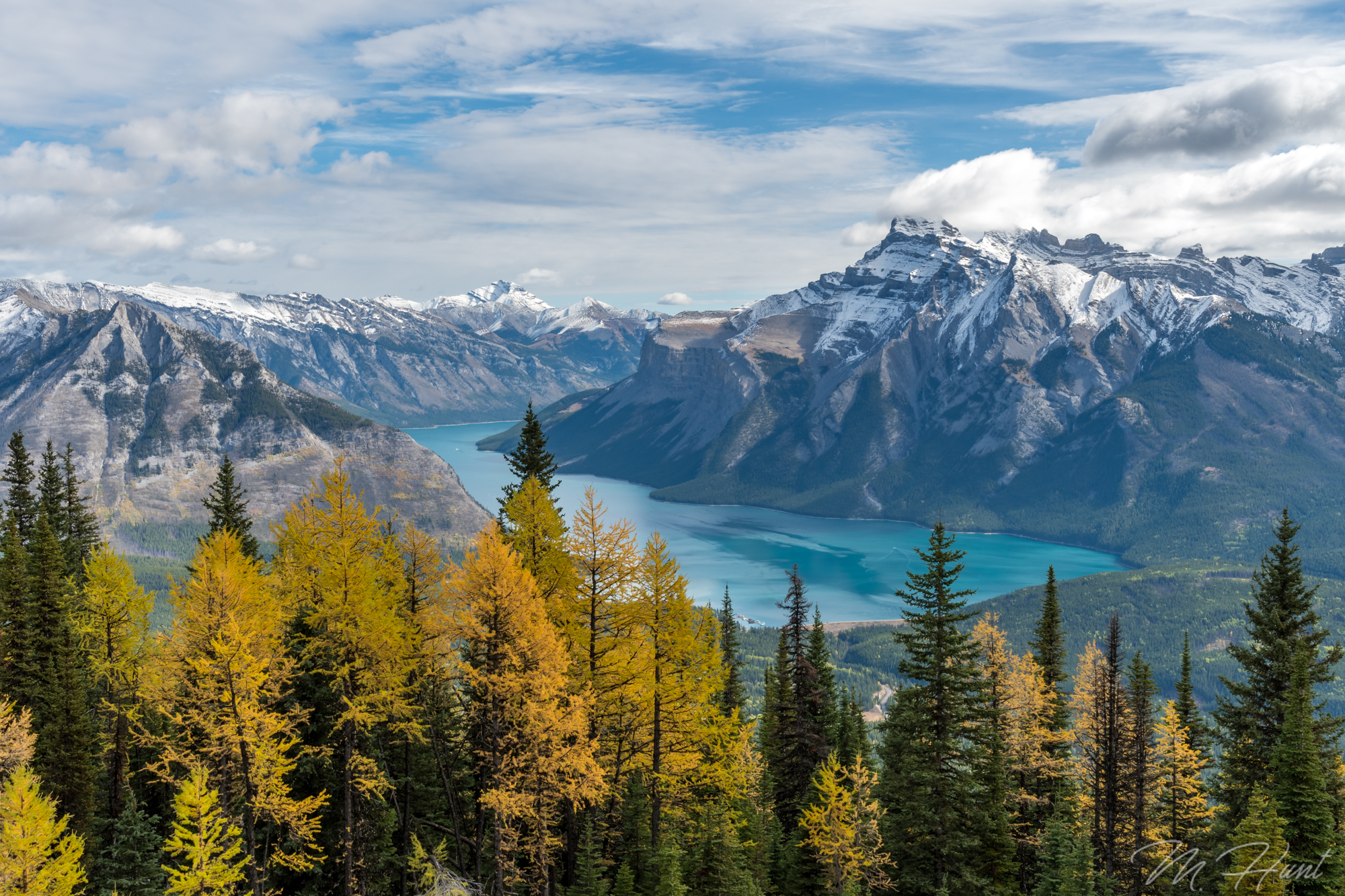
Aqua colored Lake Minnewanka. Golden larches. Snow-capped jagged peaks. Lush green pine forest. I’m not sure it could get much better!
This hike did not end with a summit, but it did end with quite a view! The hike was tough, especially the last mile or so, that seemed to be at a 45° grade. I wasn’t quite used to the elevation yet, so I was huffing and puffing as I made my way up. In spite of cool temperatures, I was still sweating.
The dense pine forest was so peaceful. The climb was so rewarding. The view was out of this world. This was a spectacular moment, and the photo may be my best of 2017.
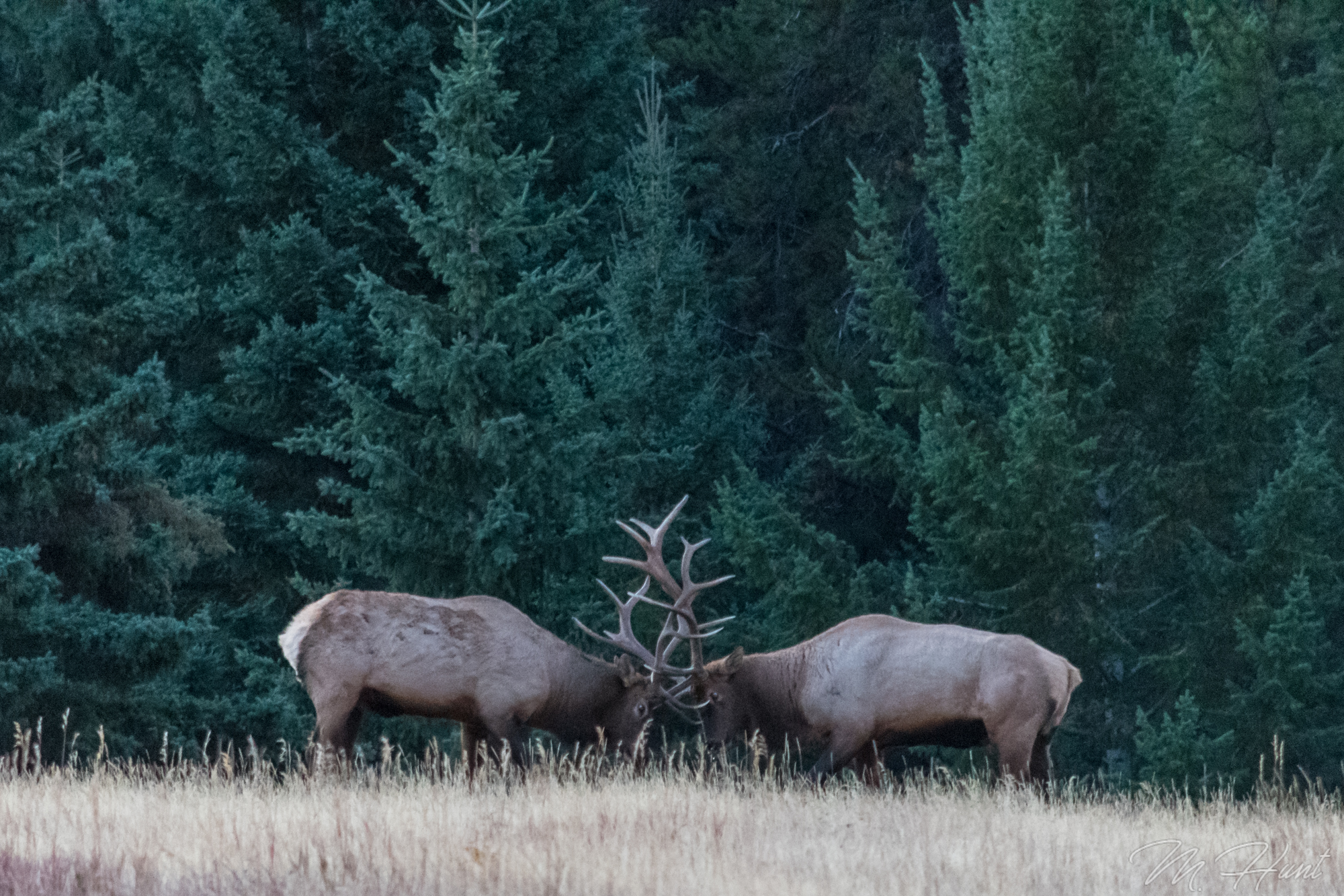
I woke up early on one of my last mornings in Canada to photograph the sunrise at Two Jack Lake. Shortly before arriving at the lake, there is a meadow the size of a handful of football fields. There wasn’t much light out at this point, but I could clearly see a couple big bull elk in the field. I snapped a few photos, then headed to the lake for sunrise, hoping the elk would still be present upon my return.
Not only were they still there, but neither one of them wanted the other to be there! Now in some better light, they were duking it out at the far end of the field. I was far enough that I needed all of my 300mm lens, but close enough that I could hear the crack of the antlers every time they butted heads. What a special unexpected treat that morning!


![20180630_131629[1]](https://hunt.style/wp-content/uploads/2018/07/20180630_1316291.jpg?w=584)