Rugged Wilderness

From now on I’ll be posting short stories around a single photo or video. This will allow for much more content to share! It has been a long time since I last posted, so it’s time to play catch up!

DSC_9989

This shot was taken from Moraine Lake Road after a long first full day in Canada. Somewhere around 14 hours at this point, where I drove all the way up to Jasper. This wasn’t even one of my top 5 shots that I was after that day, but after some editing, it has become one of my favorites!

The sun was just getting ready to set, and I had just seen Moraine Lake for the first time. I was starving, as I hadn’t eaten much that whole day. Some granola bars in the morning, and beef stew with some outstanding bread at Sunwapta Falls in Jasper for a late lunch.

What I love about this scene is that it is the essence of the Canadian Rockies. Raw, rugged, untouched wilderness. A dense pine forest in the foreground, with jagged mountains above, capped with a glacier and a light snow. Speckled among the pines on the upslope of the mountains are some golden larches, not far from losing their needles for the winter.

Ahhhh… I love autumn in the mountains!

9/24/2017

The Top of Texas

I have an idea. Instead of just visiting all 50 states, why not summit the tallest peak in each of the 50 states? Sure, in some cases this is not that exciting, like in my birth state of Indiana, for example. The highest point of Indiana is just a spot you drive to and walk a short distance. Woo. But in the western states, there are actual mountains to climb, and how cool would it be to say I’ve reached the highest point in all 50 states?!

Whether I accomplish that or not, I could at least start with my current home state’s highest peak. That would be Guadalupe Peak located in Guadalupe Mountains National Park. This is actually one of the least visited National Parks in the country, ranking 48/59 in 2016 with 181,839 visitors (for comparison, the #1 park was Great Smoky Mountains with over 11 million!). Given its location, that does make some sense. In the middle of the Permian Basin, oil wells dominate the region, and there are no cities or even large towns nearby. There are no hotels within about an hour of the park, and the campgrounds are small. It’s just not an easy park to visit, especially if you plan on staying for more than a day or two.

For me it was about an 8 hour drive. In order to accomplish this over a weekend, I had to leave immediately following work on Friday evening, drive to Midland (about 5 hours) and stay the night, then get up early (I mean REALLY early; 4 am!) to complete the drive and begin the hike by sunrise. So that is what I did!

Preparation is the key to success. If I were to complete this hike, I’d definitely need plenty of fuel! Take a look at my selection of goodies!

DSC_9129

I started my hike just before 8 am. It’s 4.2 miles from the trailhead to the summit, with a gain in elevation of just over 3,000 feet to reach the summit at 8,749 feet above sea level. This park is known for its wind, so I had watched the weather for a while, and found a weekend with almost no wind. It was also pretty warm, so the long-sleeve shirt and jacket I had with me were not even needed.

Wildlife in this park includes black bears, mountain lions, and mule deer, among others. I didn’t see any bears or mountain lions, but I did run into a few mule deer. Two grown females, and three young ones, probably yearlings.

DSC_9178

They weren’t too sure about me, but they didn’t run away, either. I always love running into wildlife. Such a treat! Love these animals!

The first mile or mile and a half of this trail is the steepest. Good news and bad news, I guess. You certainly don’t ease into the hike, but on the plus side, you get the hardest part out of the way first. It also means the views get pretty spectacular pretty quickly.

You get a little bit of everything on this trail. There is some loose rock, some slick rock, open desert area, and pine forests. In the morning the trail starts in the sun, but then goes into the shade on the western slope, as the trail levels out somewhat. It’s a welcome break after that initial steep ascent in the sun.

Perhaps my recent increased activity level helped, or perhaps it was due in large part to frequent stops to take photos, but this hike ended up being less strenuous than I had anticipated. It took 3 hours and 15 minutes for me to reach the summit from the trailhead. Without all of the breaks, I think if I really pushed it I could do it in around 2 and a half hours.

There’s a big silver pyramid marking the summit, with a lock box containing a register. I signed the register, and took a break to eat a few Kashi bars, drink some water, and take some photos at the summit.

I’m well aware of the fact I’m not making any fashion statements with that outfit! But that was the only moisture-wicking shirt I had, and the shorts are actually convertible pants, which are very convenient when you’re not sure what the temperatures are going to be like.

Going up is your cardio workout, and coming back down is without a doubt your leg workout! My quads were burning by the last mile, and of course that would be the steepest part! It’s almost easier to jog down. I did not take any breaks on the way down, and it only took an hour and a half!

At that point I took the opportunity to get my entrance sign selfie, and then decided to head up to Carlsbad Caverns (about 45 minutes north).

I had originally planned on camping at the park and going to Carlsbad Caverns in the morning, but the campground was full. As it turned out, that was a very bad time to visit Carlsbad Caverns. It was absolutely packed, and I just didn’t have time to go through it all, so I was in and out, and did not see the most interesting sections. Oh well. I had to get to the next spot that I wanted to photograph, which was the salt flats! But first, I had to stop and get the iconic shot of El Capitan!

DSC_0021-HDR-Edit

Then it was off to the salt flats. I assumed it was okay to drive on them. There were no signs to tell me otherwise! There were also plenty of tire tracks, so out onto the flats I went. Pretty cool place!

DSC_0038

That would be a really great spot to shoot the sunrise. Maybe some other time. After that I made the drive to Prada Marfa. It is located in the middle of nowhere on US-90 in southwest Texas. No, it’s not an actual Prada store. It’s a sculpture by artists Elmgreen and Dragset. It’s not even in Marfa, it’s in Valentine. Marfa is another 26 miles to the southeast.

It originally contained actual Prada shoes and purses, but was vandalized 6 days after it was completed, and those items were stolen. They were then replaced with knock-offs.

DSC_0083

Since my camping plans were spoiled, I then decided to drive all the way to Odessa to stay in a hotel room for the night. I was completely exhausted by the time I got there, but it left me with just a little over a 5 hour drive on Sunday to get back home. So it was really a one-day adventure, lasting about 20 hours! Carpe diem!

Here is a vlog I put together on my hike to Guadalupe Peak. In the future I plan on either getting a dedicated camera for this, or at least a gimbal to stabilize the phone shots.

Bells and Aspens

Every trip I take, there is really one big shot I’m after, and in my trip to Colorado in September it was a shot of the Maroon Bells at peak fall colors, and hopefully some snow on the mountains. After a brief stop at the Great Sand Dunes National Park, I made my way through Kebler Pass, McClure Pass, Marble & Crystal Mill, and up to Snowmass Village, which is basically right next door to Aspen.

I was spending three nights there, just in case the weather didn’t cooperate, but I ended up with pretty good conditions the very first morning. Not only that, but it had snowed over the weekend, so the mountains were frosted! The only issue was, I got there a little too late! I had to park way back and walk up to Maroon Lake. As I was walking up, the first light was already hitting the top of the peaks. When I got to the lake, holy moly, it was PACKED! Literally hundreds of people, so initially I wasn’t able to get an ideal spot, but I made do.

dsc_5111

After the sun got up a bit higher, the crowd started to thin out considerably. I was able to move back to a better position in order to get the shot I truly wanted. I really think the best light here is mid-to-late morning. This was the shot I was really after.

dsc_5278-hdr-2

Conditions were nearly identical the second morning, but I had arrived much earlier, so I was able to get the very first light. I actually prefer the shot prior to the sun hitting the peaks, however.

dsc_5911

Since I already had the main shot I wanted, I did a little bit of hiking, in search of some moose. I didn’t find any, but did add another shot I was hoping to get looking through the aspen grove.

dsc_6055

Also on this second morning I decided to take a quick shot of the crowd! It wasn’t even as crowded on that morning as it had been the previous day, but as you can see, this is a pretty popular spot!

dsc_6050

If you don’t get there early, you won’t get a good spot. I’m sure it’s not so bad at any other time of year, but with the bright yellow aspen trees, the fall really is the best time to photograph this incredible place!

Independence Pass

The word independence means a lot to me. I’d consider myself a pretty independent person, going on all of these trips alone, and absolutely loving it! It’s also a goal of mine to reach financial independence so that I can take even more trips. And my evening at Independence Pass was one of my favorite evenings in Colorado.

It was really a spontaneous decision to go out to Independence Pass on my final night in Snowmass Village, as I had already captured all of the other spots that I wanted photos of. So with a free evening, I decided I’d head out east for sunset.

In Goggle map searches, I found there was a trail that led out from the parking lot to an even higher peak. There were a couple 360° pictures along this path, and the view looked pretty good. I wanted to get a sea of mountain peaks in front of the setting sun.

The drive out was gorgeous! One of the most scenic roads I’ve ever driven, with the bright yellow aspen trees, dark green pines, and snow-capped peaks amidst deep blue skies and sunshine.

I still wasn’t very well adjusted to the elevation, and in this case I was starting from an even higher elevation of 12,095 feet! While the view from the paved overlook area was good, I was in search of better.

dsc_6264

Frequent breaks along the hike were necessary, as I was getting short of breath after about 10 seconds of hiking! Seriously, that thin air is no joke! No big deal, as I had given myself plenty of time before sunset, and there were some great spots for photos along the way.

dsc_6284

I made it up to the peak I was shooting for about an hour and a half before sunset, so I had time to just enjoy the views, and hunker down to try to stay warm! It wouldn’t have been that bad if not for the wind. I had left my heavy coat in the car, so all I had was a sweatshirt, light jacket, and hat & gloves. On the eastern edge of the peak, I was able to escape some of the wind, especially if I laid down flat!

The thing I enjoyed most about this spot was… there were no other people anywhere to be seen! All week I had been in the more popular touristy spots, including the Maroon Bells, which was absolutely packed. Here was a different story. Two guys had passed me on the trail, but I’m not sure what happened to them, and they may have even turned around and gone back to the parking area, and I just didn’t see them as I was snapping photos.

The scene to the west at sunset wasn’t actually all that great. The foreground was nice, but there was not a cloud in the sky in this area to add interest.

dsc_6503-hdr

No big deal, however, as the clouds to the south and east lit up after the sun had set! I was literally pumping my fists with excitement as I captured these images! What a great call to come out here for sunset!

dsc_6518-hdr-2

dsc_6545

That first photo is one of, if not the favorite sunset photo of mine that I’ve ever captured. It’s funny how my favorite photos rarely get the most likes on Facebook and Instagram, but I think there’s a different perspective when you are the one who captured it, and actually witnessed that scene in person.

While I prefer to stay behind the camera, I decided to record a little vlog during this hike:

In my next few posts, I’ll cover the Maroon Bells, Crystal Mill, Capitol Peak, Kebler Pass, McClure Pass, and Rocky Mountain National Park. So check back if you want to see some of the beautiful fall colors!

The Elk Rut

Back when I was a kid, and still to this day, I loved watching nature shows on TV. I didn’t have cable growing up, so it was always whatever was on PBS. I specifically recall Marty Stouffer’s Wild America. Growing up in the suburbs, however, I never had the opportunity to observe wildlife in its natural habitat.

Since getting into photography, I’ve been drawn to wildlife as one of my subjects. Many have just been chance encounters on visits to National Parks, but on this trip to Colorado I made the plan to spend two nights in Estes Park with one sole purpose: to witness the elk rut.

Fall is mating season for the elk. The bulls are hormone-crazed, and for the most part the females don’t seem to pay much attention. Bugling is non-stop, though outright battles are few and far between. While watching these bull elk, you may see them digging into the ground by swinging their antlers side-to-side, urinating on themselves and the ground, then rolling around in it and the mud, covering the lower half of their bodies in dark brown sludge. I don’t think human females would find any of this attractive, but then again, I’ve never tried it.

I felt like odds were pretty good I’d see some elk, but I didn’t know that it would be such a given. I had rented this monstrosity of a telephoto lens for the sole purpose of getting some great shots of these majestic animals!

20160923_182414

I arrived around lunch time and went straight to Moraine Park, a meadow area of Rocky Mountain National Park, not very far from Estes Park. This was center stage for the elk rut, and indeed I found a bull with a large harem of about 20 cows on the far side of the meadow.

They slowly worked their way closer to the road, and I had walked out away from the road to a little rocky area where I ended up sitting down to observe this bull and his harem. There were quite a few people behind me watching this group as well, but aside from that I wasn’t totally aware of my surroundings. I hadn’t seen any other elk in the meadow, so my focus was on this group.

Then I hear this guy yelling, “Toni! Toni!” I didn’t even budge, but then I hear this Toni speaking to two ladies that were behind me, telling them to walk slowly over to her and sit down. I looked behind me, and I see this young bull no more than 20 yards away heading right for me!

dsc_6649

Alright, I decided I’d head over to huddle up with Toni and those two other ladies! Toni seemed to be pretty knowledgeable in elk behavior, stating that she hunts elk. The idea was that this young bull likely would not charge all four of us close together, and that we should sit still, and NOT start running! This young bull walked around to the other side of the rocks, picked at the brush for a little while, then walked no more than 10 feet behind us and off into the meadow! Wow!

At this point there was another bull headed this way from the other side of the meadow. He wasn’t as young, but he still wasn’t as big as the bull who controlled this large harem. At one point it looked like he wasn’t going to mess with big daddy, and walked off a bit, but he lingered. And he lingered. And gradually he worked his way closer and closer to the harem. Big daddy had enough. He got up and started chasing the young bull off!

dsc_7118

There was no battle, as this younger, smaller bull knew he’d be no match for big daddy. So he finally decided to wander off.

After getting checked into my hotel and getting some food, I ventured back to the meadow. I observed a few more bulls, only one that was very close, but there didn’t seem to be much going on. I had read the elk are more active in the evening, but to this point, that didn’t seem to be the case. So I began driving back as we had just about reached dusk.

When I got toward the front of the road, I came upon pure madness! There were at least 3 or 4 bulls and maybe 100 cows! Bulls were chasing each other and bugling, the females were squealing, and cars and people lined the road watching the show!

dsc_7339

I ended up running into my buddy again, the same young bull I saw earlier. Some of these bulls were easily recognizable due to distinct features, and for this young gun, it was his beat up antlers. He must have engaged in a battle at some point during the rut, because he was missing the end to his right antler. This time I was in the safety of my vehicle, and he walked right in front of it.

dsc_7348

I noticed how heavy he was breathing! You can see here his mouth is open; poor guy had his hormones going bonkers, and just couldn’t find a female to link up with! Maybe next year!

Day 2 started out near mid-morning, as I made the hike to Dream Lake for sunrise. I was told when I got there that I had missed some action, and that there was almost a battle. No big deal, as there was still plenty to see the rest of the morning, and I was able to get some great close-ups with much more favorable light than I had the previous day!

Such an amazing animal. I wish I’d had more time to spend watching them, and I wish I could watch them year-round! That evening I had hiked to Alberta Falls, and didn’t get back to the meadow until it was just about dark. There didn’t seem to be much going on, anyway, so I kept the camera in the bag and just observed with my own eyes.

The final morning brought rain showers, and for me I was actually trying to find some bighorn sheep. No such luck with that, but there were still plenty of elk. I saw this guy outside of the park, but close to the entrance.

dsc_7972

After that I went to the Sheep Lakes area, looking for sheep, but finding more elk! This guy was walking away from the road, but I was able to get a couple good shots in before he was only displaying his backside to my direction.

dsc_8022

I took a drive down Fall River Road, still looking for sheep, but finding another elk that was actually behind a fence, so I was able to get VERY close to him and remain safe! He didn’t seem to be to interested in finding a mate, as he was just grazing through the grass.

And with that, I was off to Denver! I have hundreds more photos of these awesome creatures, but these were some of my favorites. I hope you enjoyed looking at them as much as I enjoyed taking them!

Hoodoo Magic

It was still dark outside as I approached Bryce Canyon National Park. I had left Hurricane, UT incredibly early in the morning so that I could get to the park before sunrise. I was carefully watching the clouds, as it appeared the sun was going to be blocked, and indeed it was at sunrise!

Although it was the middle of summer, Bryce is at a higher elevation, above 8,000 feet, and it was a brisk 52° that morning! I had not really packed for cooler weather, although I did have a light jacket with me. In spite of that, I was wearing shorts and flip flops, so it was a bit chilly!

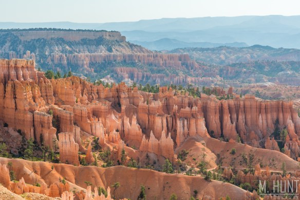
The clouds did block the sun initially, but as I found out later on, I don’t think the sunlight would have hit many of the hoodoos early on. Even after it peaked the clouds, I had to wait several more minutes before it really started to light up the whole amphitheater.

dsc_2414-2

Bryce is a magical place, and seems like another planet! How do these crazy rock formations even happen?! The hoodoos are formed by a couple of environmental factors. One is a process known as frost wedging. This area has over 200 freezing/thawing cycles each year. Snow melts, resulting in water seeping into the cracks, and then re-freezing overnight. As we all know (or should know if we paid attention in science class), water expands when it freezes. This slowly erodes the sedimentary rock, forming holes, and later these individual spires.

Rain also plays a role in the hoodoo formation. Its slightly acidic nature slowly dissolves the limestone. Different mineral deposits in the layers of the rock result in the different colors, appearing as stripes, as well as the shapes, as some layers are formed of harder rock than others. New hoodoos continue to form as old ones crumble to the ground, so it’s likely this area will look like this for many, many years to come.

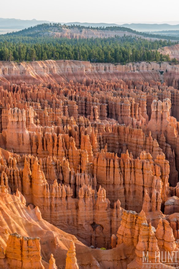
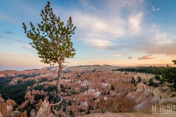
The above photo (probably my favorite, and hanging on my wall!) was taken from Inspiration Point. This is the area in the park with the most dense concentration of hoodoos, and is probably one of the most photographed. Another popular spot is around one particular hoodoo that has been named Thor’s Hammer. That was my next stop.

The sunlight bouncing off the orange walls was creating this incredible glow in this area! This is a must if you visit Bryce. You have to get out of bed early, because the morning light is the best this place looks all day!

It was here that I blew a golden opportunity that shows you why I’m still single! I had a very attractive young lady approach me and ask me to take her picture. Based on her accent, she was not American, and based on the lack of anyone else with her, she was traveling alone. Of course I’m not a one-night-stand guy, and this likely would not have led to any long-term relationship, but hey you never know. Regardless, I had wished I would have kept her in my presence at least a few minutes longer and struck up a conversation, but instead I just went back to shooting pictures of my own. Idiot.

dsc_2576-hdr

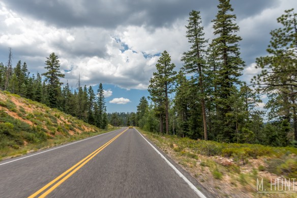
As the sun got higher, the pictures were not as great, so I decided to grab some lunch. When I got back to the park I decided to drive further in and check out some of the other overlooks.

Man… that drive was awesome. It was beautiful out there, with temps in the mid-70’s and no humidity to speak of! I put the windows down and opened up the sunroof and enjoyed the fresh air as I cruised through the pine forest. It may be a bit odd, but this was one of those moments that truly stuck out to me. The feeling at that time of not a care in the world, no worries about work, or bills, or anything. Just enjoying the present. I need more moments like that in my life!

dsc_2701

This is definitely when I’m at my happiest. They do not lie when they tell you that travel changes you. It sure has changed me. There’s no place I’d rather be than any place I’ve never been before!

dsc_2720

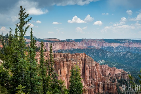
I did have to battle with some rain showers passing over the park, as you can see a little in the top left corner of the photo above. Out of the frame there’s a big dark cloud there! In fact there was even some tiny pieces of hail falling! I imagine that’s mostly due to the elevation, not the strength of the updraft for this little storm.

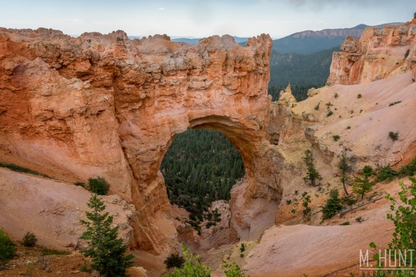
One of the stops I had to make was another often photographed feature of the park called Natural Bridge. This is a huge arch, and I didn’t realize that there’s a parking lot and overlook right there at it! I initially thought it would be a bit of a hike based on the park map. I bet this would be a great place to be in the morning as well, with some of the light bouncing off the cliff and back onto the arch.

dsc_2739

After that I got some ice cream (I’m on vacation, I do what I want), checked into my room in the nearby town of Panguitch, and came back to the park after dinner. I didn’t know if there would be much of an opportunity for any good photos at sunset since the cliffs face east, and the sun is pretty much completely blocked from this area in the evening.

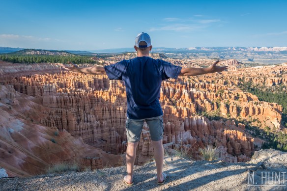
Of course I had to do my signature selfie first…

dsc_2845

I had some indecision on where to set up for the sunset, as I was watching some high clouds rolling in, and thought they just might light up after the sun went down. No such luck, but this shot turned out pretty good!

dsc_2907

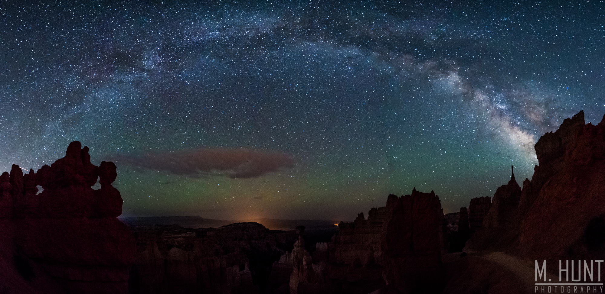
I stayed at the park after dark, and went back to Thor’s Hammer for some milky way shots! This is the time that is pretty boring, between sunset and the milky way becoming visible. It was about an hour and a half with literally nothing to do. I just stood there by my camera. Ha! I don’t know the stars very well, but I’ve come to recognize a triangle of bright stars that show me where the milky way will be. Of course you have to account for the rotation of the Earth, but it gives me a pretty good idea of how to set up well before it’s dark out.

I decided to try something I’ve never done successfully… take a panorama of the entire milky way. It is quite a challenge, because the Earth’s rotation means those stars are not stagnant, you’re shooting long exposures, and it took 9 vertical shots to complete the entire pano. What helps tremendously is the degree markings on my tripod. I know that if I turn it 15° (or was it 10°?) I’ll have enough overlap between pictures for it to stitch together in Lightroom. And finally, I got it to work!

dsc_2993-pano

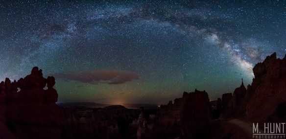
I actually tried to do longer exposures for the foreground and make a composite, but for some reason it would never line up. Something may have been off with the lens correction, though I tried making the pano before and after applying a lens correction, and it still didn’t line up. Oh well, this shot works. If you’re in a dark room, you can see the details and see Thor’s Hammer in the middle of the photo.

That wasn’t the only milky way shot I had planned, however! The park entrance faces south, so the sign has the milky way behind it! I’m not sure if this is possible at any other National Park. I know this is the only park I’ve seen photos of it done.

That shot proved to be difficult simply because of all of the traffic going by as people exited the park! The headlights were way too bright, and ruined the photo repeatedly. I finally got a shot where the car was still well off in the distance, and it lit up some of the trees nicely along the road. I used two exposures here so that I could use a low ISO on the sign, and not have any noise at all! That was very simple to blend using layers in Photoshop and setting that layer to “lighten”.

dsc_3023-edit

Even though Bryce Canyon is a relatively small park, there is still a lot of it that I didn’t have time to explore! I didn’t do any hiking at all, so that is one thing I’d like to do if I ever return. What am I saying… WHEN I return! I’d also like to come back in the winter and get some shots of the hoodoos draped in a bed of fresh snow!

I hope you enjoyed these pictures, and I hope you’re now considering a visit to Bryce Canyon! You definitely won’t regret it!

Delicate Arch: A Utah Landmark

On my trip through the National Parks of southern Utah, there was one shot in particular that I was after. I wanted to get a shot of the milky way through Delicate Arch. Delicate Arch is symbolic of Utah; in fact it appears on their license plate. Formed of Entrada Sandstone, the arch opening stands 64 feet tall and 45 feet wide. It is the largest free-standing arch in Arches National Park.

Delicate Arch is not one that cannot be driven right up to and seen with a short walk. It requires a fairly strenuous hike of 3 miles round trip, with a 480 foot elevation gain. In the summer heat, this is made even more strenuous, and there isn’t a whole lot of shade along the trail! Since I wanted to be there for sunset as well, I completed this hike at probably the worst possible time of day, the late-afternoon, when it was well in excess of 100 degrees! The sign at the beginning of the trail recommends bringing 2 liters of water with you for this hike. I had finished off 1 liter by the time I reached the top.

Once I was at the top, however, I was able to sit in the shade and cool down, and it wasn’t bad at all. That’s the advantage of the dry heat! In spite of the heat and the relatively demanding hike, it was pretty crowded up there, but I fully expected that.

Even with the crowds, you can get a good angle on the arch from several different spots, so it’s not really an issue. The biggest issue is that everyone and their mother wants to get a picture of themselves standing underneath the arch! There was actually a line, and one at a time they’d walk out, take a few pictures, then the next person or group would come in.

Once the sun began to get lower in the sky, however, there was one brave photographer who yelled across the way for those people to clear the arch and give everyone 10 seconds for a clear shot!

dsc_3139

This is another one of the top shots I was after on this trip, and one that had been two years in the making, ever since I was originally set to spend 4 weeks in Grand Junction, CO, just 2 hours away. The only thing that would make it better is if the La Sal Mountains had snow on the peaks! I guess I’ll just have to go back in the early spring to get that shot!

Later on as the shadows were creeping up on the arch, and the light at the top of the arch was even more brilliant, I took it upon myself to yell across the way and ask for another 10 seconds to shoot!

dsc_3182

You see the difference in the color there as the sun gets lower, and the light turns to a more brilliant orange. I just wish the arch was sitting a little higher, or there wasn’t anything blocking the sun at the bottom of it at this point. Nonetheless, that was quite a beautiful moment, and in this scenario, a completely cloud-free sky was another thing I had been hoping for.

The lack of clouds was absolute requirement after the sun set if I were to get the #1 shot I came for with the milky way! After the sun went down, the crowd slowly started to die down, and for a moment I thought it would just be myself and one other photographer there to shoot the milky way, but by the time darkness had set in, half a dozen or more photographers showed up.

To get this shot, I had planned on doing two separate exposures. One for the milky way itself, with a high ISO to take in more light. I then wanted to do a separate exposure for the arch at a lower ISO for less noise, lit by my flashlight. I made sure the other photographers were okay with me light painting for a couple minutes, because I was still doing a long exposure for this. If you light paint on a high ISO, you really only need a flash.

Back on the computer, I combined the two images in Photoshop. Since I’m not that skilled with the various methods of cutting parts of layers out, I did this all by hand when zoomed way in. In addition, my camera creates this odd noise on long exposures with these little purple, red, blue and yellow lines. I went through all the dark spots on the foreground with the spot removal tool and took literally thousands of these little specs out by hand! This one image has about 4 hours of labor in it, but the end result was well worth it!

dsc_3283-4

Want a print of this image? Visit my Etsy store to order! I got an 18 x 24 inch canvas of this printed for my wall at home, and it looks great! Just contact me if you want to order any other images that are not in my current inventory on Etsy!

dsc_4289

Canyonlands All-Nighter

There were two places I wanted to photograph in Canyonlands National Park, which was about an hour drive from Moab. One involved the Milky Way, the other involved sunrise, so I just planned to stay out there all night, rather than drive an hour back just take a quick nap, then turn around and go right back to where I came from!

My first stop was at False Kiva. This trail is not marked on any park map, but if you just Google it, you’ll find it. The trailhead is not officially marked by any plaque, or even a parking area, but the trail itself is easy to see. The reason for this is that the park doesn’t want thousands and thousands of visitors to this place. I can’t find a whole lot of information on it, and I believe it’s because there’s a lot they don’t really know about it. I do know that it is an archaeological site, so they are likely still trying to figure out more about it. A kiva is basically a wall of stones in a circle. They could be used to live in, or have spiritual ceremonies. This one is called False Kiva because its origin and exact use are unknown.

I had seen good shots of this location at sunset, as well as at night with the Milky Way, so I wanted to get both. I set out about two hours before sunset. All of the info I had read put this hike at about an hour. That would give me plenty of time. Most of the trail was well-defined, flat, and easy. There was one section of slick rock where it was difficult to determine where to go, but I could see where cairns once stood, and as I went I stacked these rocks back up to make new cairns so that I could find my way back in the dark!

The hard part comes at the end of the hike, where you actually descend below the alcove where False Kiva is, then pass it, then have to climb back up to it. That brought out some sweat! Oh yeah, I forgot to mention that when I was eating dinner prior to leaving Moab, I checked the temperature and it said 109!

When I got to the site, I noticed a metal box sitting behind a big rock. I opened it and found some information on the site, some rules, pens & a notepad that a lot of other hikers & photographers had signed. I went ahead and signed that notepad myself!

DSC_3385-HDR

Sunset was beautiful from this spot! The last light hit those cliffs and turned them red, and the hazy air allowed the horizon to generate a beautiful orange hue, while further up the sky remained blue. Gorgeous!

Okay, I have a confession to make. I screwed up on the Milky Way shots! First of all, I didn’t realize how far to the left the Milky Way would be as it first became visible, so I had to move my camera from this spot, and I really didn’t like that angle. Also, what I should have done was take a shot of the canyon prior to full darkness so that I could create a two-image composite with a visible canyon, and visible Milky Way in the sky. I did not, and without that, you really can’t discern any part of the canyon. Add to that the fact that most of the sky became obscured with cloud cover after the sun had set.

Being at this place… wow. I was a little bit anxious, to be honest. I was looking forward to getting back to my car! I was a bit worried about finding my way back in the dark, and it just felt odd being out there all by myself. The only sign of any human life out there were the planes flying overhead. It was a little eerie, so when it appeared the clouds were going to be around for a while, I decided I didn’t want to wait any longer, and around 11 pm I decided to hike back.

I made it back to my car without any issues, and from there took the very short drive to the Mesa Arch parking area, where I would try to get some sleep in while waiting for morning. I wasn’t quite sure what time I needed to get up and hike to the arch, as I had heard people start getting set up HOURS before sunrise to get a good spot! I set an alarm for 3 am, but to be honest, I barely slept any.

The sky ended up clearing not too long after I got there. I did get to enjoy quite a few meteors, and a seriously dark night sky, with a bright Milky Way clearly visible. This was pretty amazing! I just love being out in the middle of nowhere looking at the stars on a clear night.

The first car pulled up about 2 hours before sunrise. That was my que, time to get my stuff and hike out to the arch! Those two French guys would beat me there, and in fact I got a little lost on the trail trying to find it! The trail is a loop, and I ended up doing the loop, missing the part where you turn off the loop to go to the arch! Eventually I found it, and was glad to find they weren’t set up where I wanted to be anyway!

Slowly but surely other photographers started trickling in. We didn’t like what we saw in the sky… clouds! There was a very brief period where the sun had a clear part to shine through, and the shutters went off like machine guns!

There was still plenty of room for me to take the camera off the tripod and get some different angles, so I took advantage of that. The best use of the D500’s 10 frame per second speed for me is handheld HDR bracketing! I can fire off three consecutive images with very minimal movement of the camera, allowing them to easily line up in Lightroom later. I did a lot of that on this trip.

After just a few minutes, the sun was gone behind the clouds. I wondered if that would be it, but I wasn’t even thinking about leaving just yet! I was taking a close look at the clouds, and figured there would be a chance of the sun poking back out once it got higher in the sky. I wasn’t sure how much orange glow would be on the bottom of the arch at that point, but I sat and waited. Others did not, including those two French guys who were there first. They gave up, packed up and left! BIG mistake, because the clouds cleared 10 minutes later, and this happened:

YES! This is what I came here for! That orange glow on the bottom of Mesa Arch is just incredible, and you know what? I’m glad we had those clouds, because it adds some interest to the rest of the sky in the photos! I left Mesa Arch feeling great… really tired… but great, knowing that I had gotten the shots I came here for!

Before going back to Moab, I stopped by Dead Horse Point State Park. It was right off the road that went to Canyonlands anyway, and I figured morning would be a good time to be there. To be honest, I’d rather have been there earlier, but that wouldn’t have been worth missing the magic at Mesa Arch!

DSC_3984-Edit

There’s actually a poster of this place hanging on the wall in our office right behind me where I stand at my computer. However, it’s just a view of the canyon, so I didn’t know about all these Juniper trees along the ledge! I was happy to see that, as I’m always looking for some foreground interest to add to these vast landscape photos. It definitely makes for a more interesting photo!

I couldn’t leave without doing my signature selfie, though!

DSC_3958

I was SO tired at that point, but it was all worth it! I got back to Moab, and after eating some breakfast, hopped into bed!

Chasing Zebras

In the medical field there is a thing called chasing Zebras. A Zebra represents those rare, but serious conditions that a patient could have, but more than likely doesn’t. If you’re chasing a Zebra, you may end up running a ton of unnecessary tests, and get nowhere. Or if the patient actually has a Zebra, you may end up saving a life!

In this case, I’m referring to a different Zebra, but I’m still not referring to the animal. When I was at the Bryce Canyon visitor’s center, I was browsing through the books, and found one titled Photographing the Southwest. This was the first volume in a series, and was focused solely on southern Utah. In this book I found this amazing slot canyon called Zebra Slot Canyon. I had seen pictures of this place before, but I didn’t really know where it was. I looked it up, and it was only an hour and a half from Bryce! It left a 4-hour drive to Moab, where I was headed next, but I HAD to go visit this place!

This is well off the beaten path. To start, you’re in the small town of Escalante, UT, population 779. From there, it’s an 8 mile drive down a ROUGH gravel road. A 4WD vehicle is not necessary, however, and my Accord got there just fine.

When I got to the parking area, there was one other guy who was just leaving his vehicle and heading out on the trail. I’d end up catching him later on and passing him, and then I never saw him again.

The hike out to Zebra Canyon is really pretty easy and flat. There are some sections that get a little confusing, but you can always look around and find the trail.

My feet were still in bad shape from my hike through the Zion Narrows, so the hike was a bit painful at times. I found it was worse in sand, because I couldn’t really keep the pressure off those wounded areas. There were several sections where I had to cross the Halfway Hollow creek, and while it was muddy, there was no water running through it, so I would get some mud on the sole of my hiking shoes, but it wasn’t a big deal. Then I came up to this…

20160727_104603

What would you do? I walked up and down the bank here, and while some sections became more narrow, there weren’t any narrow enough that I could jump over. I had to cross it. I thought I may be able to throw some rocks down and create a little bridge, but the rocks were just sliding in the mud on the bottom, not to mention covered with slippery mud on top! The risk of a fall was high, so I decided to forego that. Alright… off with the shoes and socks! Yep, I crossed that sucker barefoot! When I came out on the other side my feet were caked with mud! I knew I was close, so I just continued on barefoot, but that became an issue shortly as the sand was filled with spiny little twigs that were getting stuck to the bottom of my feet. Ouch! I eventually sat down and scraped off as much mud as I could, and put my socks and shoes back on.

It wasn’t much further until I finally came upon the mouth of the slot canyon. Hooray!

20160727_092246

I had read that there could be pools of water at the beginning of this canyon, their depth of which would depend on how much rain had recently fallen. This water was stagnant, dirty, and disgusting! There were tadpoles swimming in it, and these huge water bugs on the surface. But there was no other option if I wanted to get to the sweet spot of the canyon, so into the nasty water I went! I was at least prepared for this by wearing swimming trunks. I had hoped it would only be knee deep. Well, that hope vanished about 4 feet in. It was clear I wouldn’t be able to wear my backpack, so I came back out and took all of my stuff off, took my cell phone and keys out of my pocket, and went back just to test how deep that water was.

DSC_3052

It got deeper. A lot deeper! All the way up to the top of my chest! Did I mention it was dirty water? I know I didn’t mention it was also cold! I’m not sure if it was the fact it was cold, dirty, or that it was in this narrow space, but for whatever reason it literally took my breath away. I was afraid it would continue to get deeper, which would not have allowed me to bring my camera in, but luckily it did not.

It did, however, get more narrow. VERY narrow. To the point where my feet wouldn’t even fit on the bottom, so they were getting scrunched and scraped all the way through that joint! I was still angry at my water shoes from Zion, so I did not have them with me. I wasn’t going to get my hiking shoes wet either, so I continued to do this barefoot. Finally I hit the point where the water ended, but there was still a very narrow section to navigate. The best way to do it was to “sit” against one wall with my hands behind me, and put my feet (bare feet, I remind you) up on the other wall, and… I’m not sure what you call this… spider walk? Whatever you’d call it, it takes a lot of energy to do! And at one point I slid down the face of the walls, giving me rock burns on my right palm, and left sole.

It’s certainly not easy to get to the back of the canyon, where the magic is located. But in the end, it’s worth it. I scraped up my feet quite a bit, particularly my right foot, where the wounds had been healing, but they were both opened back up, and would prove to be an issue for the remainder of the week as a result. Anyway, I had finally reached the sweet spot, and this is what I saw…

DSC_3066

WOW, was it beautiful! That wasn’t even the best view, however. After going further in and looking back, the view was even better!

Because of the difficulty in getting back there, I had only brought my camera, which I just carried above my head through the water, and hung around my neck for those sections requiring use of both hands. I really wanted to go back and get my tripod so that I didn’t have to shoot at ISO 2000, but after going a little ways I decided it was too much trouble, and I’d just come back some time in the future and be better prepared!

I was also somewhat pressed for time, as I had a 4-hour drive to get to Moab, check-in to my room, and then get up to Delicate Arch for sunset, or really well before sunset for the photos I wanted. So I didn’t stay any longer.

When I got back to the front where all of my stuff was, I realized… I never took my wallet out of my back pocket! Oh, goodness. It was soaked, of course! So on the drive to Moab, I came up with a decent way of drying it out…

20160727_150239

I was so dirty and gross, and I’m sure I smelled terrible, but it was all worth it! I’ll definitely go back sometime, but this time I’ll be better prepared! Perhaps the best part was that I had the canyon to myself the entire time! On the way back, I passed a group of four who asked me if they were on the correct trail to Zebra Canyon. It was a young couple with two older women. I informed them what they were about to encounter, and showed them pictures as motivation, but I really doubt the two older women were able to make it back there! Then when I was almost to the parking area, I passed a large group of boys and a couple men. I’m not sure if they were headed all the way to the canyon or not. But chances are good if you head out there in the morning hours, you’ll be all alone, or will only see a few others!

The Narrows

Ahhh, it sure was good to be back at Zion National Park! This is without a doubt one of my favorite places, even though I had previously spent all of one day there! After a long drive out from Dallas, I had spent the previous night in nearby Kanab, UT, about an hour away. I arrived at Zion relatively early in the morning, and planned on heading to the last stop on the shuttle, the Temple of Sinawava, which was where The Narrows hike began.

Before I got through the east end of the park, however, I ran into a huge group of bighorn sheep, so I had to stop and take some photos! I originally only saw one standing on top of a rock, so I turned around, and by the time I got back in that area several cars had stopped, and I noticed quite a few. Then more showed up. Then more showed up! They were all females with the exception of one male ram. Of course I focused on snapping pictures of him, because those big horns (hence the name) are pretty impressive!

This has to be one of my favorite animals. And sure, you can see bighorns and other animals in an enclosed space, like a safari drive, but there’s just something so much more magical about seeing them out in the wild. Obviously these animals have been around for a long time, as they can be seen in petroglyphs throughout this area of southern Utah. What a magical creature!

Moving on through the park, I got to the visitor’s center and got my bag put together and caught the shuttle. It takes quite a while to get all the way to the final stop in the canyon. I’d recommend getting there much earlier than I did, and catching the very first shuttle out. I had to wait in line for a while just to get on the shuttle. It was mid-morning, I forget what time, but this seems to be the busiest time of day for the park shuttle.

The trail starts on the Riverside Walk, which is a well-maintained path, so that part is easy. This goes for about a half-mile I believe. Where this ends, it’s time to go straight into the Virgin River! I purchased a pair of water shoes with a pretty thick sole on them a few days prior to leaving, however I was never able to find any neoprene socks. I noticed that many others had the same shoes on, with sizes noted by markers. They were rentals. I should have done more research! Those shoes (and socks) looked legit, and much better than my $25 water shoes. As it would turn out, I really could have used those! The insoles in my shoes came loose, and were shifting all around inside the shoe, and rubbing against my feet. I ended up with skin scraped off in four different areas, two on each feet. The most problematic of them all were on the inside “corner”, if you will, of each foot right at the ball of the foot. This spot on the right foot in particular would end up being an issue for the entire duration of the trip! So if you do the Zion Narrows hike, be sure you are properly outfitted for it! I’d recommend using one of the local outfitters to rent those shoes. I couldn’t tell you which one those people got them from, but I’m sure a little research would reveal that!

DSC_1782

At any rate, I’m not sure how far out I went, but I hiked for about 3 hours before deciding to turn around and come back. The water was never even waist deep, and most of the time was only ankle deep. In this 100-degree weather, it was much more pleasant hiking in the mostly shaded, cool waters of the Virgin River! I heard one guy saying you could go as far as 14 or 15 miles down the river if you are so inclined. Obviously I didn’t go quite that far! But it’s a good hike for the family, and you can make it as long or as short as you want.

As far as a photography standpoint, well that was tough. The river was absolutely packed with people, so I had a hard time finding spots where I could get a clear shot. On many occasions, just as I thought I had a clear shot, a group of 10-15 more people would start hiking through. At one point right after I had set up my tripod, this kid literally sat down RIGHT in front of my camera. Ugh, really kid?! I just glared at him, and after a minute or so he started moving out of the frame. I’m sure it wouldn’t be so packed during the cooler months, but at those times a wet suit may not be a bad idea!

Enough words, on to the photos! Contact me for prints or canvases of any of these photos!

DSC_1811DSC_1872DSC_1834-EditDSC_1821