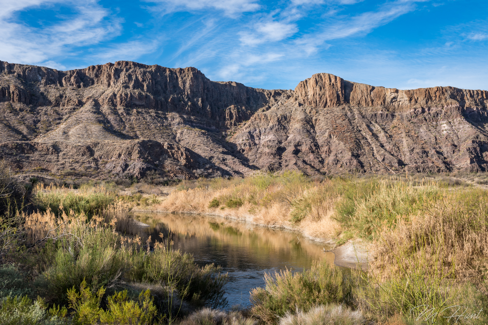
A couple weeks ago I took a crazy trip to Big Bend! Why was it crazy, you ask? Because Big Bend is a 9 hour drive, and I did it on a normal weekend.
I left work at 5 pm on Friday evening, and after fighting the DFW traffic & rain (which makes traffic about 8 gazillion times worse) I arrived in Terlingua at around 2:15 am. I “slept” in my car at a free campsite, waking before the sunrise.
I went out from there to take some photos and video, and then went mountain biking on the Dome Loop in Big Bend Ranch State Park.
I met some great people in the parking lot of the visitor’s center, Danny & Darlene, and went biking with Danny, then hung out with them afterward in their Sprinter camper van. They have been traveling the country while living in the van for the past 11 months! I’m jealous!
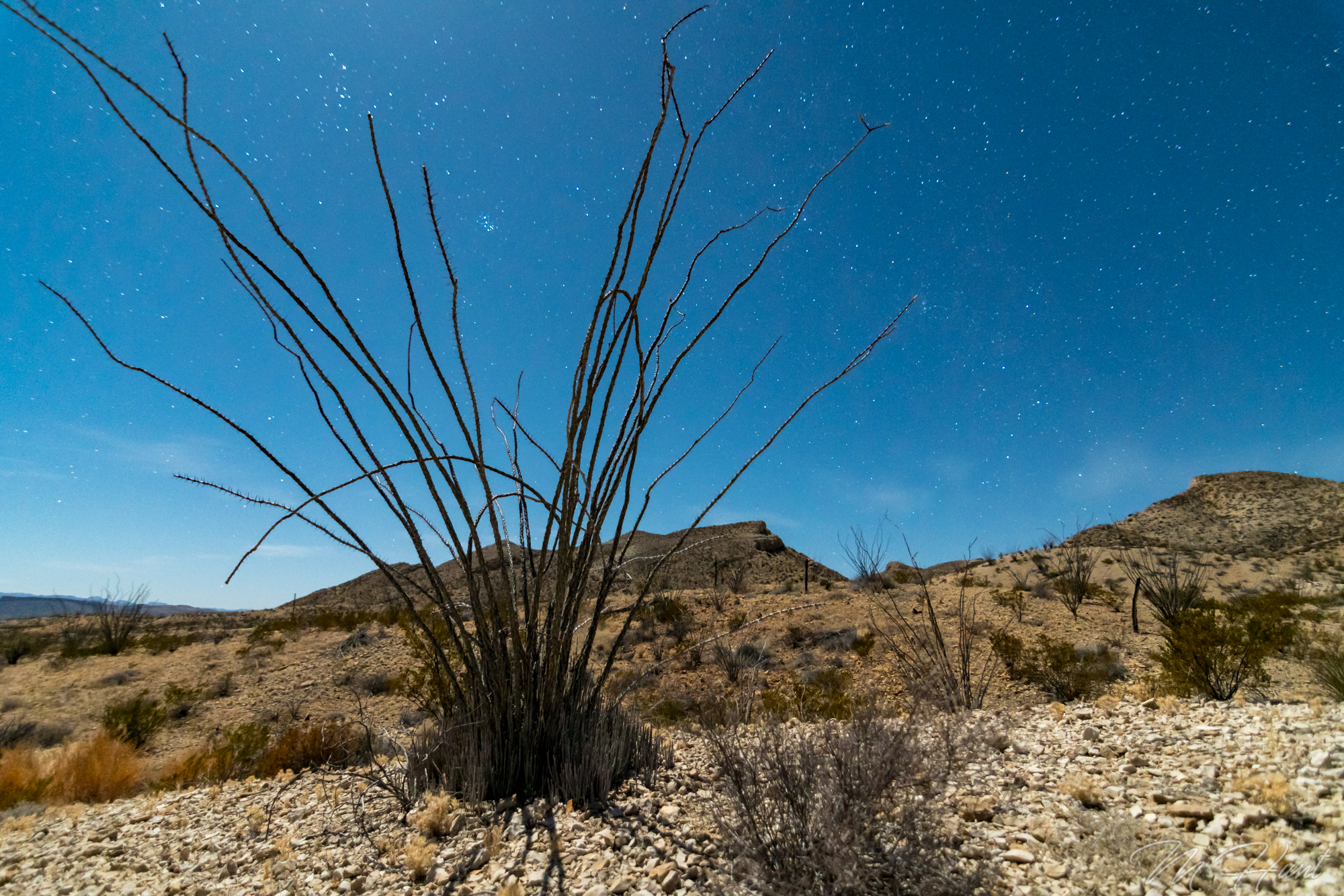
That night I stayed at a legit campsite, which was amazing, and the moonlight lit up everything!
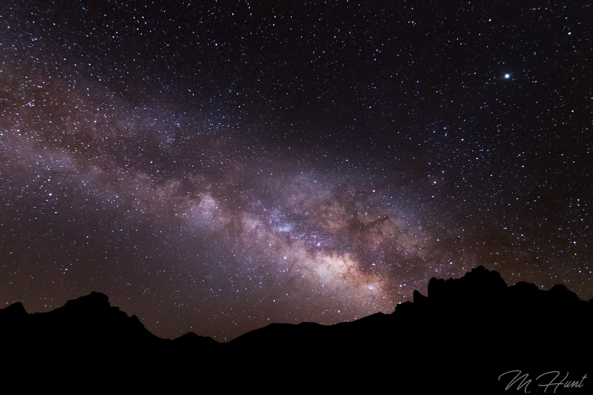
After a much better (but chilly) night of sleep, I rose super early to make a 45 minute drive to Big Bend National Park to shoot the Milky Way.
Sunday morning was the Lajitas Airport trails, and then the 9 hour drive back home!
Don’t let a lack of money or lack of time keep you from traveling. This trip cost roughly $100 (gas + $10 for the campsite) and didn’t require any PTO time. Yes, I spent 18 hours of my weekend driving, and far less than that sleeping, but you only get one life, so CARPE DIEM! The memories are worth far more than the time and the money spent.
I have an idea. Instead of just visiting all 50 states, why not summit the tallest peak in each of the 50 states? Sure, in some cases this is not that exciting, like in my birth state of Indiana, for example. The highest point of Indiana is just a spot you drive to and walk a short distance. Woo. But in the western states, there are actual mountains to climb, and how cool would it be to say I’ve reached the highest point in all 50 states?!
Whether I accomplish that or not, I could at least start with my current home state’s highest peak. That would be Guadalupe Peak located in Guadalupe Mountains National Park. This is actually one of the least visited National Parks in the country, ranking 48/59 in 2016 with 181,839 visitors (for comparison, the #1 park was Great Smoky Mountains with over 11 million!). Given its location, that does make some sense. In the middle of the Permian Basin, oil wells dominate the region, and there are no cities or even large towns nearby. There are no hotels within about an hour of the park, and the campgrounds are small. It’s just not an easy park to visit, especially if you plan on staying for more than a day or two.
For me it was about an 8 hour drive. In order to accomplish this over a weekend, I had to leave immediately following work on Friday evening, drive to Midland (about 5 hours) and stay the night, then get up early (I mean REALLY early; 4 am!) to complete the drive and begin the hike by sunrise. So that is what I did!
Preparation is the key to success. If I were to complete this hike, I’d definitely need plenty of fuel! Take a look at my selection of goodies!
I started my hike just before 8 am. It’s 4.2 miles from the trailhead to the summit, with a gain in elevation of just over 3,000 feet to reach the summit at 8,749 feet above sea level. This park is known for its wind, so I had watched the weather for a while, and found a weekend with almost no wind. It was also pretty warm, so the long-sleeve shirt and jacket I had with me were not even needed.
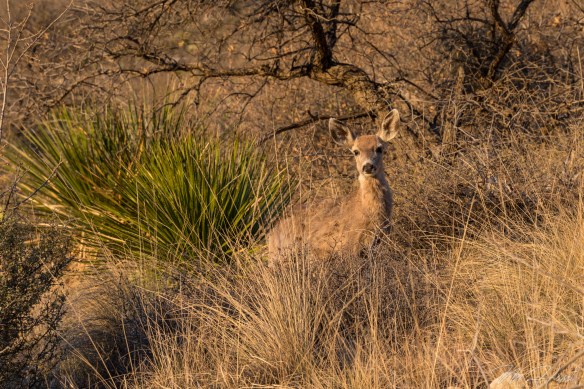
Wildlife in this park includes black bears, mountain lions, and mule deer, among others. I didn’t see any bears or mountain lions, but I did run into a few mule deer. Two grown females, and three young ones, probably yearlings.
They weren’t too sure about me, but they didn’t run away, either. I always love running into wildlife. Such a treat! Love these animals!
The first mile or mile and a half of this trail is the steepest. Good news and bad news, I guess. You certainly don’t ease into the hike, but on the plus side, you get the hardest part out of the way first. It also means the views get pretty spectacular pretty quickly.
You get a little bit of everything on this trail. There is some loose rock, some slick rock, open desert area, and pine forests. In the morning the trail starts in the sun, but then goes into the shade on the western slope, as the trail levels out somewhat. It’s a welcome break after that initial steep ascent in the sun.
Perhaps my recent increased activity level helped, or perhaps it was due in large part to frequent stops to take photos, but this hike ended up being less strenuous than I had anticipated. It took 3 hours and 15 minutes for me to reach the summit from the trailhead. Without all of the breaks, I think if I really pushed it I could do it in around 2 and a half hours.
There’s a big silver pyramid marking the summit, with a lock box containing a register. I signed the register, and took a break to eat a few Kashi bars, drink some water, and take some photos at the summit.
I’m well aware of the fact I’m not making any fashion statements with that outfit! But that was the only moisture-wicking shirt I had, and the shorts are actually convertible pants, which are very convenient when you’re not sure what the temperatures are going to be like.
Going up is your cardio workout, and coming back down is without a doubt your leg workout! My quads were burning by the last mile, and of course that would be the steepest part! It’s almost easier to jog down. I did not take any breaks on the way down, and it only took an hour and a half!
At that point I took the opportunity to get my entrance sign selfie, and then decided to head up to Carlsbad Caverns (about 45 minutes north).
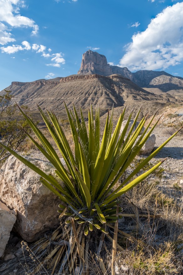
I had originally planned on camping at the park and going to Carlsbad Caverns in the morning, but the campground was full. As it turned out, that was a very bad time to visit Carlsbad Caverns. It was absolutely packed, and I just didn’t have time to go through it all, so I was in and out, and did not see the most interesting sections. Oh well. I had to get to the next spot that I wanted to photograph, which was the salt flats! But first, I had to stop and get the iconic shot of El Capitan!
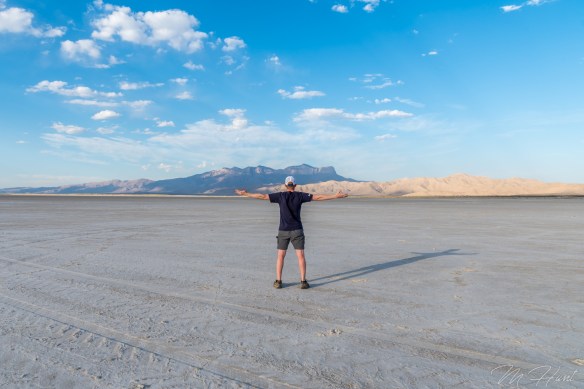
Then it was off to the salt flats. I assumed it was okay to drive on them. There were no signs to tell me otherwise! There were also plenty of tire tracks, so out onto the flats I went. Pretty cool place!
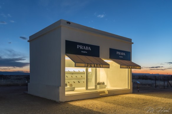
That would be a really great spot to shoot the sunrise. Maybe some other time. After that I made the drive to Prada Marfa. It is located in the middle of nowhere on US-90 in southwest Texas. No, it’s not an actual Prada store. It’s a sculpture by artists Elmgreen and Dragset. It’s not even in Marfa, it’s in Valentine. Marfa is another 26 miles to the southeast.
It originally contained actual Prada shoes and purses, but was vandalized 6 days after it was completed, and those items were stolen. They were then replaced with knock-offs.
Since my camping plans were spoiled, I then decided to drive all the way to Odessa to stay in a hotel room for the night. I was completely exhausted by the time I got there, but it left me with just a little over a 5 hour drive on Sunday to get back home. So it was really a one-day adventure, lasting about 20 hours! Carpe diem!
Here is a vlog I put together on my hike to Guadalupe Peak. In the future I plan on either getting a dedicated camera for this, or at least a gimbal to stabilize the phone shots.
Since I was not able to camp at White Sands, and started the morning an hour further west, I had a little more time than I had expected on day 2 of my road trip. Heading into this day, stopping at Saguaro National Park in Tucson, AZ was a possibility, but now it was certain!
I was very excited to cross the state line into Arizona. It’s a state I had been wanting to visit for such a long time, and I was finally there! What beauty there was for my eyes to behold. All of the various plants lining the desert floor, while the mountains overlooked them. These are the kind of mountains I like. The rest of the land around them is perfectly flat!
Saguaro National Park is actually split into two separate sections; the Tucson Mountain District to the west, and the Rincon Mountain District to the east. I only stopped at the latter, and went around the loop drive, which was about 8 miles total.
Despite this being one of the hottest and driest deserts in all of North America, there is quite a variety of plant and animal life here, and I was able to sample a good bit of it all!
Of course this park is named after the most recognizable cactus of them all, the Saguaro. These cacti are exclusive to the Sonoran Desert, and symbolic of southern Arizona. They can live for up to 200 years, and grow to be 60 feet tall. When fully hydrated, they can weigh over 4,000 pounds! The blooms of the Saguaro represent the Arizona state flower.
I was also lucky enough to get to see some animal life while in the park! I ran into these two right on the road! A rattlesnake and a Gila monster!
Maybe I’m a little crazy, but I had been hoping to see a rattlesnake! I was definitely watching my step everywhere I went, because I don’t want to invade their space, but I did want to see one with my own eyes, as well as get a photo. I think they are beautiful creatures! How lucky was I to be able to do just that in one single trip around the loop drive?!
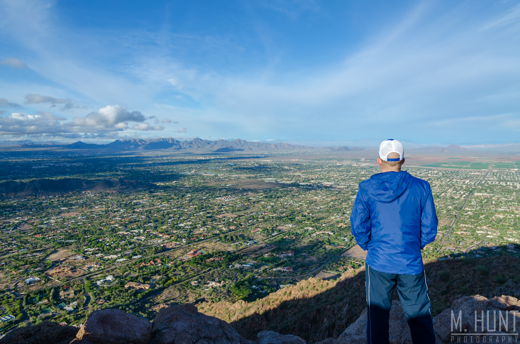
After leaving the park and picking up some tacos for lunch, it was on to Phoenix! I just had a couple of goals for my visit to Phoenix; hike Camelback Mountain, and get a good skyline shot.
It was raining when I arrived in Phoenix. What kind of luck is that? How many days a year does it rain in Phoenix, like three?! I was watching the radar closely, as well as noting the clearing visible to the west. The rain did let up by late afternoon, so off I went to Camelback!
Temperatures were only in the 60’s, yet I was still sweating like crazy on this hike, or climb, as it would be better described! There are two options to get to the summit; the Cholla Trail, and the Echo Canyon Trail. I took the Echo Canyon Trail, which is 1.23 miles in length, with a 1,280 ft elevation climb. The summit of Camelback is 2,704 ft above sea level. If you ever plan on doing this hike, bring plenty of water! I only had one bottle, and downed the whole thing before reaching the peak, and it was a cool evening! I can’t imagine doing this in the typical desert heat!
The views from the top are fantastic, of course.
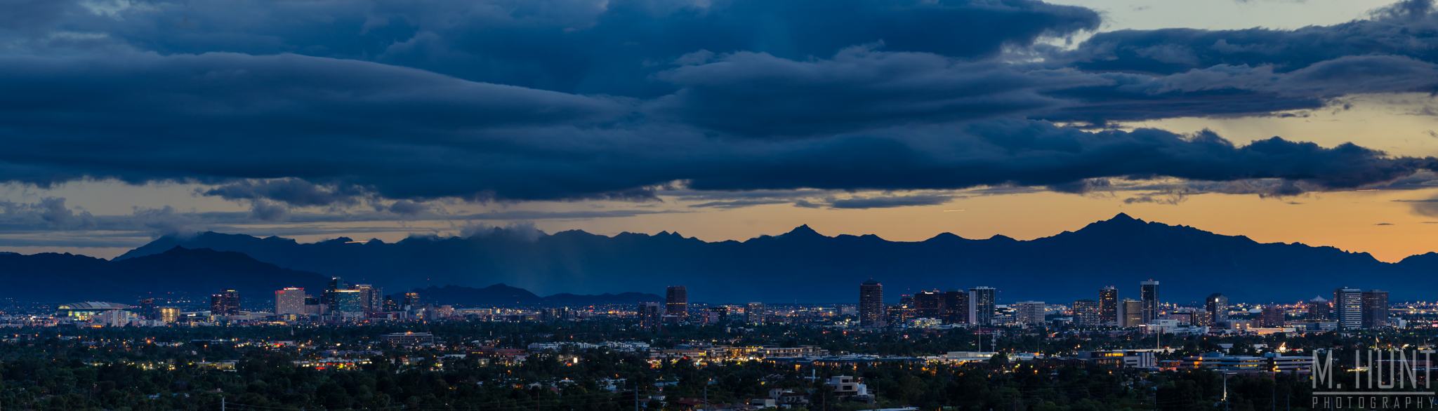
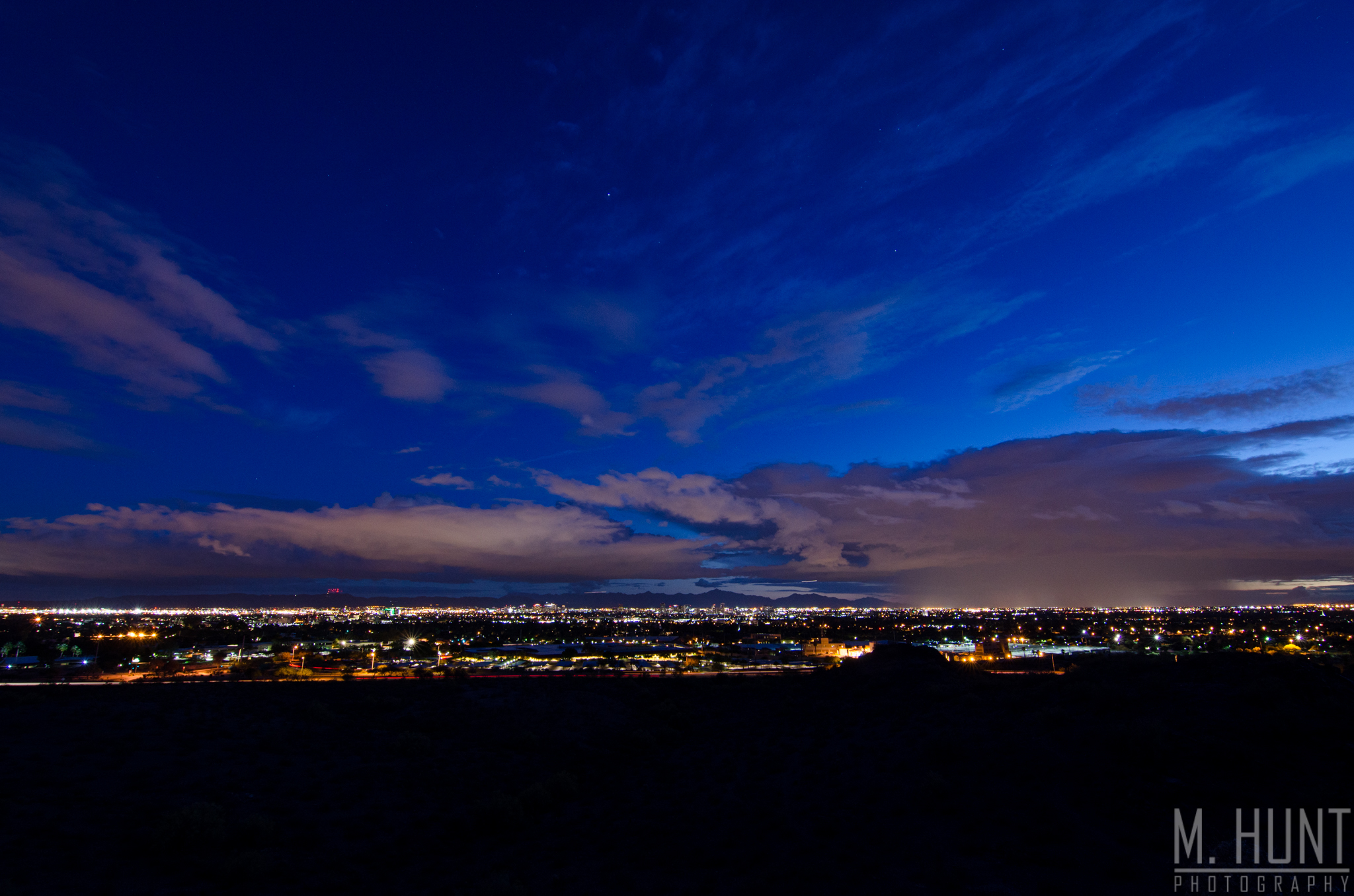
Since they ticket anyone in the parking lot after dusk, I had to get down and go elsewhere for my skyline shot. Luckily I had spoken to a park employee before the hike and found out that the Piestewa Peak Park, not too far away, stayed open until 11 pm. So that is where I went to get my skyline shots. I didn’t actually climb to the peak, as that was about the same climb as Camelback. Instead I formed my own trail in a way, and went to a smaller peak to the south, where I was able to capture the skyline.
Conditions weren’t perfect for the shot I really wanted, but since it was my only night in Phoenix, it would have to do! It was certainly better than nothing. The Phoenix skyline itself is not anything spectacular, but the mountains in the background make it special! Blue hour from that spot was pretty cool, too!
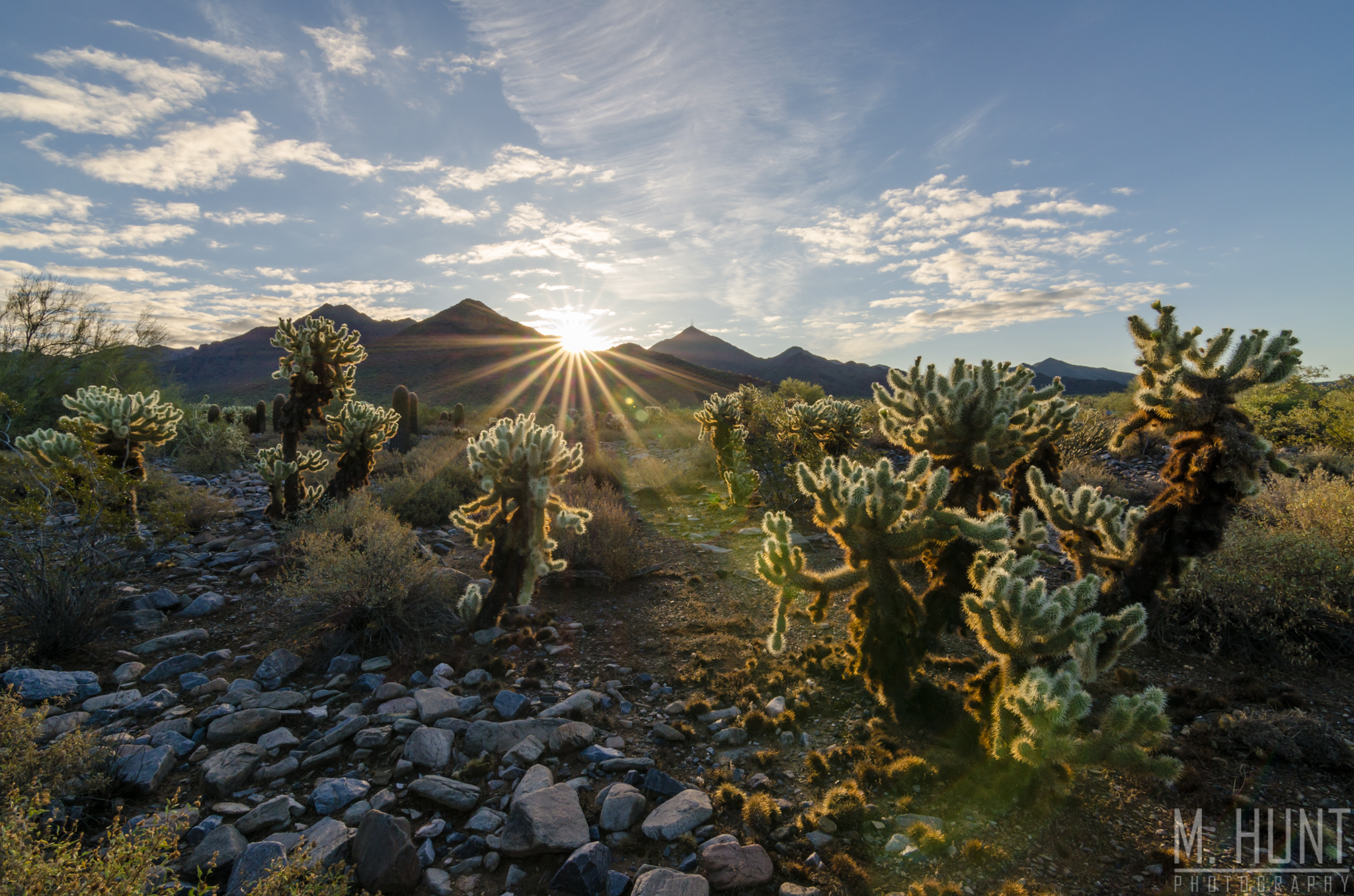
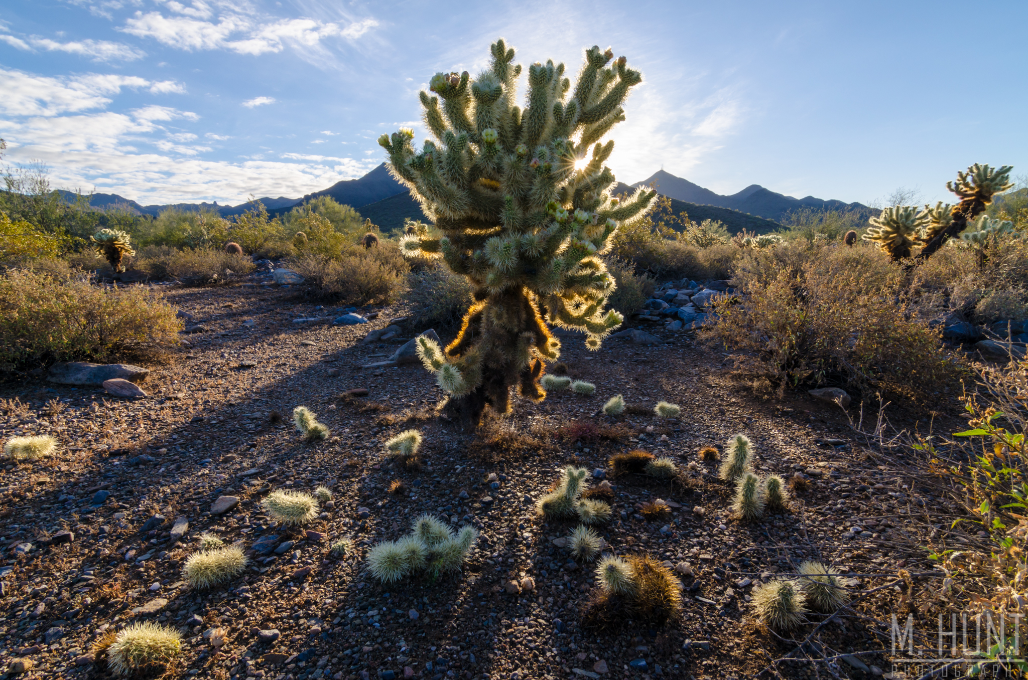
I did have one more shot I wanted to get in the Phoenix area before leaving, and I pursued that the following morning. I wanted to get a good shot of the jumping cholla cactus with the backlit sun at sunrise!
For this shot I went to the McDowell Sonoran Preserve Gateway Trailhead in North Scottsdale. I had scouted out this location the day before. The only downside to this spot is that McDowell Mountain blocked the very early morning sun, so by the time the sun peaked over the mountain top, it was a bit more intense, and not quite as golden in color. Still, the shot turned out okay!
The jumping cholla is an interesting cactus, and probably my favorite one! It is covered in spines, which feature tiny barbs, helping them stick to anything they touch! You have to be extra careful around these cacti. The branches are segmented, allowing smaller sections to break off. This is how the seeds are spread, and why you typically see these cacti in groups that are close together. In the picture below, you can see all of the little segments littering the ground around the cactus!
What a cool plant! I really enjoyed the Phoenix area. It is beautiful, of course, and features a wide array of outdoor activities and life. If I lived there, I’d hike Camelback a few times a week for a cardio workout! I hope to visit again some day and stay longer, but if I don’t get the chance to, I’m glad I can say that I conquered Camelback Mountain!