Exploring Northwest Arkansas’ Newest Trail – Fitzgerald Mountain – Springdale, AR

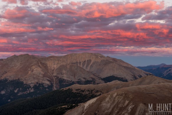
This past weekend I headed up north from Dallas to my favorite weekend getaway destination for mountain biking, Bentonville, AR! It’s getting to the point, however, where you just have to say Northwest Arkansas, because there are so many trails all over the place, with more new trails opening all the time, that Bentonville isn’t the only city worth a visit!

Just 20 minutes to the south in the city of Springdale, a brand new trail system had just opened up at Fitzgerald Mountain. 7 miles are currently open, with another 3 miles to be opened in the fall. As of right now, you park at Bayyari Park to access the trail, but they will be building a new trailhead and parking lot as well, I believe off Dodd Ave.

These trails were so much fun! There are many undulations that can be pumped to gain or maintain speed, or even get some air, as well as bigger jumps, gap jumps (that I skipped!), and so many berms! The rock work is like art, including a couple of rock berms that are unlike anything I’ve ever seen!

Here’s a list of the individual trails, their difficulty rating, and a short description:

1. Butterfield Trail – Blue – 2.4 miles – I’d describe it as a flow trail, with some jumps, berms, and a few rock features.
2. Best Trail Ever – Black – 3.0 miles – The name says it all! This trail is fantastic, with some beautiful rock work, including some technical sections, jumps, berms, and some good speed! It’s a blast!
3. Fitzgerald – Blue – 0.6 miles – A shorter loop, with very little elevation change, and more natural trail.
4. 1857 – Black – 0.1 miles – This is an alternate route off of Fitzgerald for those looking for some technical challenges. Lots of rocks to navigate here. I did not ride this trail, but got a good look at it.
5. Coyote Cave – Black – 0.6 miles – Best ridden from north to south so that it’s mostly downhill, this trail features more fantastic rock work, a small cave, more flowy berms, several jumps, and a big gap jump near the bottom.

Here’s how I’d ride it:
Starting at the trail head at Bayyari Park, go north on Butterfield. The first intersection you’ll come to will be with Coyote Cave. Save it for the way back. Next you’ll reach a split in Butterfield. Go right to take you to the hub of all the other trails (you’ll have to return to ride this section again later in order to cover all trails). You’ll climb up and reach another split, where you should stay right. This will take you to the center hub, where the trail circles around a tree in the middle, and the other trails branch off of this circle.

Go around to Fitzgerald. You’ll have two options, take the one on the left. Shortly after heading down Fitzgerald you’ll have the option of adding 1857 (on your left). Pick back up on Fitzgerald until you come to the entrance to Best Trail Ever on the left. Take it and head right (counter-clockwise). You’ll come back to this intersection and continue on Fitzgerald to the left, taking you back to the central hub.

From the hub, go back down Butterfield, and head right at the intersection. This will take you around the loop, allowing you to enjoy mostly downhill. You’ll meet up with the intersection you were at during the early stages of the ride, and take the same trail (to your left this time) that heads back up to the central hub.

Once you’re back at the hub, you can start your run down Coyote Cave. When that meets back up with Butterfield, head back south to the trailhead.

That route covers all of what is currently open!

Bow Summit

DSC_9684

Oh Peyto Lake, how beautiful you are! Yes, the color of the water is real! It’s caused by the glaciers scraping tiny particles of the limestone, thus suspending these particles, known as rock flour, in the water. That is how it gets that unique turquoise color.

You’ll notice something else at Bow Summit. It’s at a higher elevation than Lake Louise to the south, so temperatures are much cooler, and it’s more likely you’ll run into ice & snow, as I did in late September.

It was mostly cloudy at this point in the morning, but a brief break in the clouds revealed a spotlight onto the mountains for the perfect shot!

Independence Pass

The word independence means a lot to me. I’d consider myself a pretty independent person, going on all of these trips alone, and absolutely loving it! It’s also a goal of mine to reach financial independence so that I can take even more trips. And my evening at Independence Pass was one of my favorite evenings in Colorado.

It was really a spontaneous decision to go out to Independence Pass on my final night in Snowmass Village, as I had already captured all of the other spots that I wanted photos of. So with a free evening, I decided I’d head out east for sunset.

In Goggle map searches, I found there was a trail that led out from the parking lot to an even higher peak. There were a couple 360° pictures along this path, and the view looked pretty good. I wanted to get a sea of mountain peaks in front of the setting sun.

The drive out was gorgeous! One of the most scenic roads I’ve ever driven, with the bright yellow aspen trees, dark green pines, and snow-capped peaks amidst deep blue skies and sunshine.

I still wasn’t very well adjusted to the elevation, and in this case I was starting from an even higher elevation of 12,095 feet! While the view from the paved overlook area was good, I was in search of better.

dsc_6264

Frequent breaks along the hike were necessary, as I was getting short of breath after about 10 seconds of hiking! Seriously, that thin air is no joke! No big deal, as I had given myself plenty of time before sunset, and there were some great spots for photos along the way.

dsc_6284

I made it up to the peak I was shooting for about an hour and a half before sunset, so I had time to just enjoy the views, and hunker down to try to stay warm! It wouldn’t have been that bad if not for the wind. I had left my heavy coat in the car, so all I had was a sweatshirt, light jacket, and hat & gloves. On the eastern edge of the peak, I was able to escape some of the wind, especially if I laid down flat!

The thing I enjoyed most about this spot was… there were no other people anywhere to be seen! All week I had been in the more popular touristy spots, including the Maroon Bells, which was absolutely packed. Here was a different story. Two guys had passed me on the trail, but I’m not sure what happened to them, and they may have even turned around and gone back to the parking area, and I just didn’t see them as I was snapping photos.

The scene to the west at sunset wasn’t actually all that great. The foreground was nice, but there was not a cloud in the sky in this area to add interest.

dsc_6503-hdr

No big deal, however, as the clouds to the south and east lit up after the sun had set! I was literally pumping my fists with excitement as I captured these images! What a great call to come out here for sunset!

dsc_6518-hdr-2

dsc_6545

That first photo is one of, if not the favorite sunset photo of mine that I’ve ever captured. It’s funny how my favorite photos rarely get the most likes on Facebook and Instagram, but I think there’s a different perspective when you are the one who captured it, and actually witnessed that scene in person.

While I prefer to stay behind the camera, I decided to record a little vlog during this hike:

In my next few posts, I’ll cover the Maroon Bells, Crystal Mill, Capitol Peak, Kebler Pass, McClure Pass, and Rocky Mountain National Park. So check back if you want to see some of the beautiful fall colors!