The Iconic Trail 401 in Crested Butte

I could not ride for 6 days in Crested Butte and not hit Trail 401! It always comes up whenever I read an article about mountain biking in Crested Butte. I considered it a must for this trip!

Trail 401 is a bit longer in distance than Teocalli Ridge, but the elevation gain is about the same. The difference is that it’s split into two climbs on Trail 401. I knew it’d be another tough climb, regardless. I live in flat lands 500 or so feet above sea level, so being over 11,000 feet at the peak of these trails after climbing roughly 2,000 feet was going to be difficult no matter what!

It’s a little over 6.5 miles from the parking area to the start of the downhill, and most of it is on the road. This road climb wasn’t too bad. I was actually able to pedal the majority of it. At one point I passed a couple who were driving up the road and stopping to take in views along the way. The guy asked me, “is that fun?” I replied, “Not yet!”

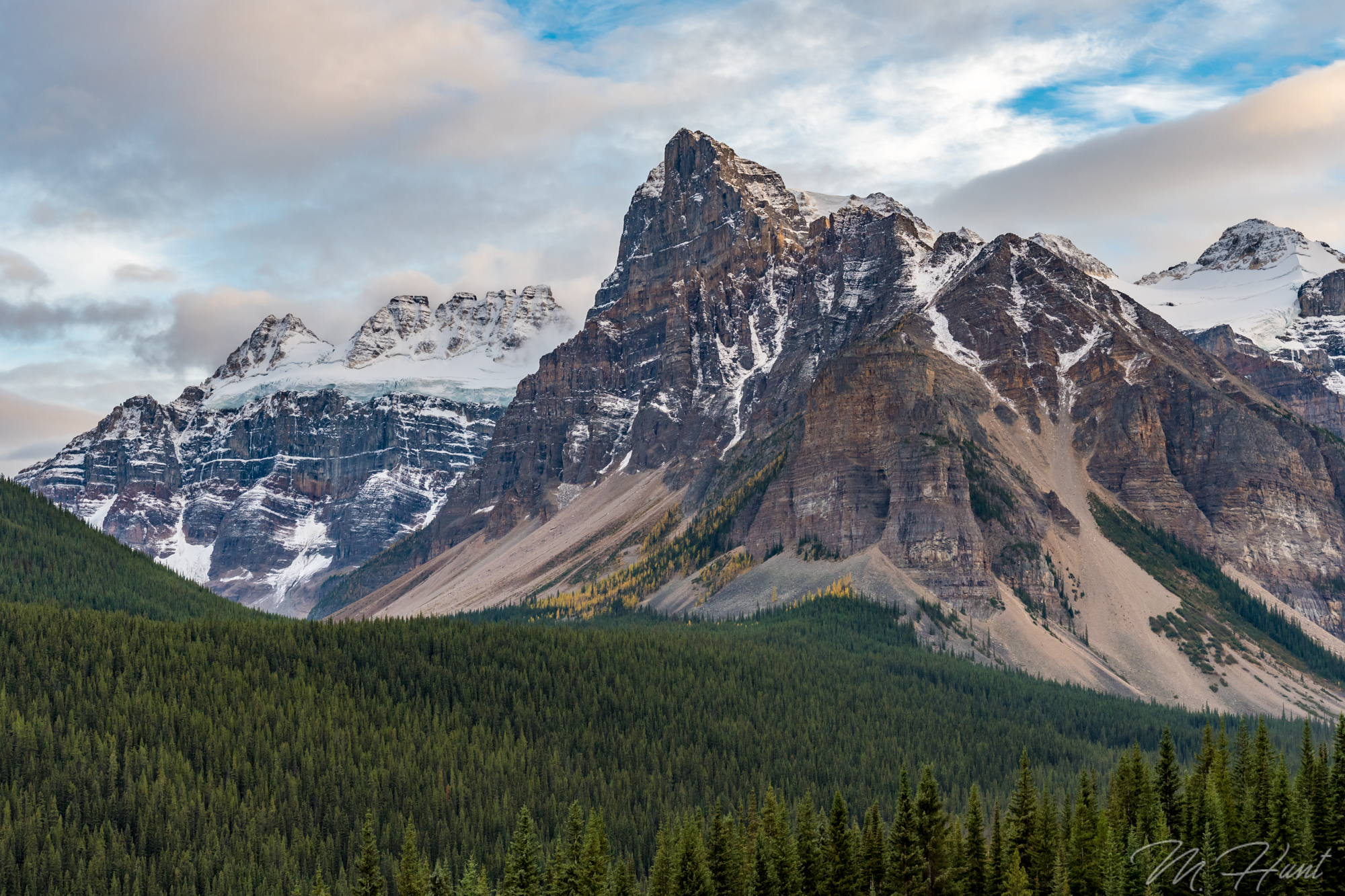
Even if it was just a workout at this point, the views were spectacular. I think that’s really the case no matter what trail you ride in Crested Butte!

Once you enter the singletrack, it really starts to go up. I had to walk a lot on this section. After venturing into the forest, with the wind picking up, and my body drenched in sweat from all the exertion, I started to get quite chilly! I’d take my jacket off to try to dry up some of the sweat, but I really needed the jacket on to cut that chilly breeze. I was also a little paranoid. It was very quiet. I was all alone. There are bears and mountain lions in this area. My head was on a swivel. Suddenly, my heart skipped a few beats as I heard a loud cracking & crashing, ending with a low-pitched thud! A tree had fallen nearby! I didn’t see it, but it couldn’t have been too far away. As if I wasn’t paranoid enough about animals that could eat me, now I had to worry about trees falling on me!

Needless to say, despite my gasping for oxygen-depleted air, and rubber-like thighs, I continued to pedal as much of this singletrack as I could. At this point I was getting mad at the fact this climb wasn’t over yet! But a little anger is always a good thing when you need to push yourself physically!

There was no rain in the forecast on this day, but as I approached the top, there was clearly rain off to my west. I better hurry up, I thought. I wasn’t too worried about it once I got going downhill, as I’d be going fast, and I’d be moving away from the dark clouds. Luckily I was soon starting the descent, and I never looked back.

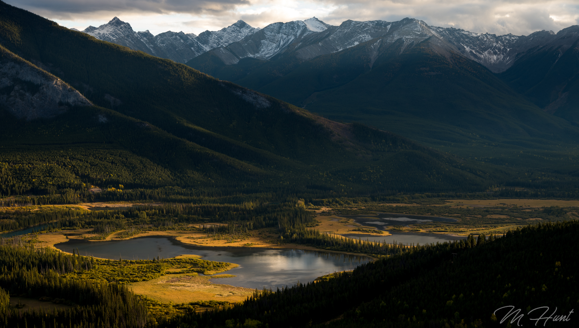
The descent starts on a lot of straight trail, but it’s fast, and has some great views of the valley! In the summer, this part of the trail is lined with wildflowers, but in the autumn they have all turned brown and lost their will to stand up straight.

After kindly asking a couple cows to remove themselves from the trail, I got into a bit more flowy section with loamy hero dirt! I was really working on my cornering all week, focusing on leaning the bike, while keeping my torso upright and fighting the urge to squeeze the brake levers. I felt really good out there on Trail 401! The primo dirt conditions certainly didn’t hurt matters.

I made it down the initial downhill in a hurry! As a matter of fact, close to the top 10% on Strava! Well, I’m sure most people stop a million times to take in the views and snap a few photos, so take that with a grain of salt. Though I do think at this point in the week I had already gotten faster than I was on day 1.

20180920_131747

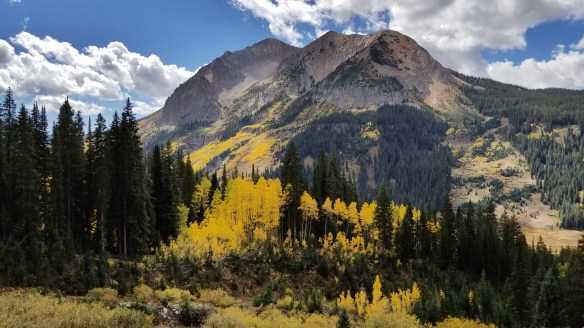
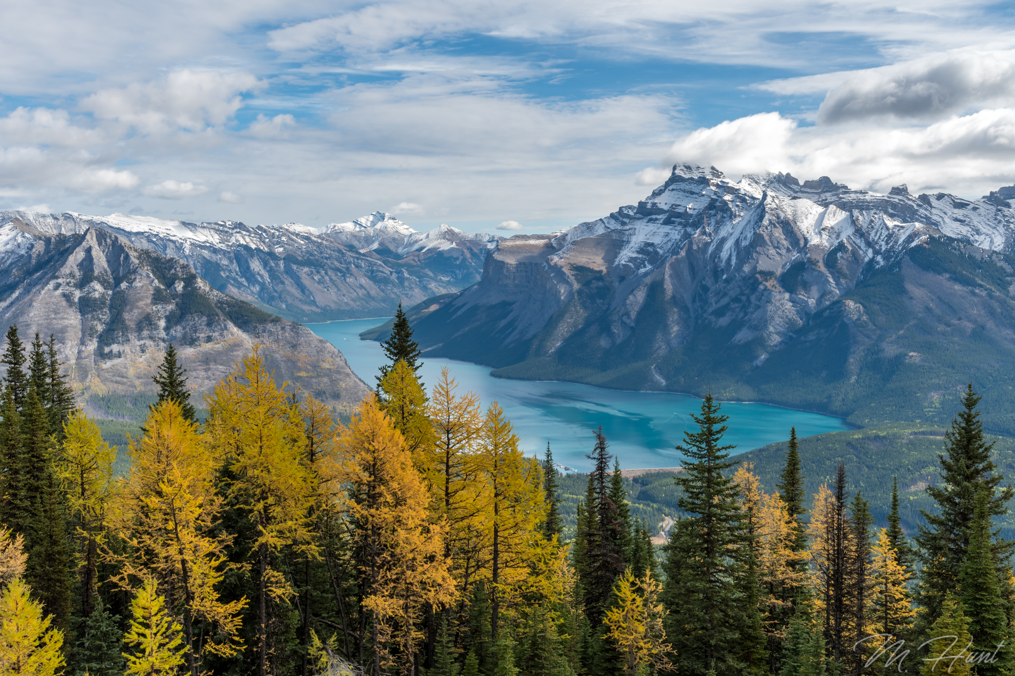
On the second climb I came across one of the most beautiful landscapes I’ve seen looking over toward Gothic Mountain. Goodness! Just look at it!

Do you smell that? Oh wait, I can’t send smell through blogs. Dang it! I really wish I could. The wonderful aroma of the pine forest is one of my favorite scents! You won’t hear this from many people, but… I must say, Trail 401 smells great!

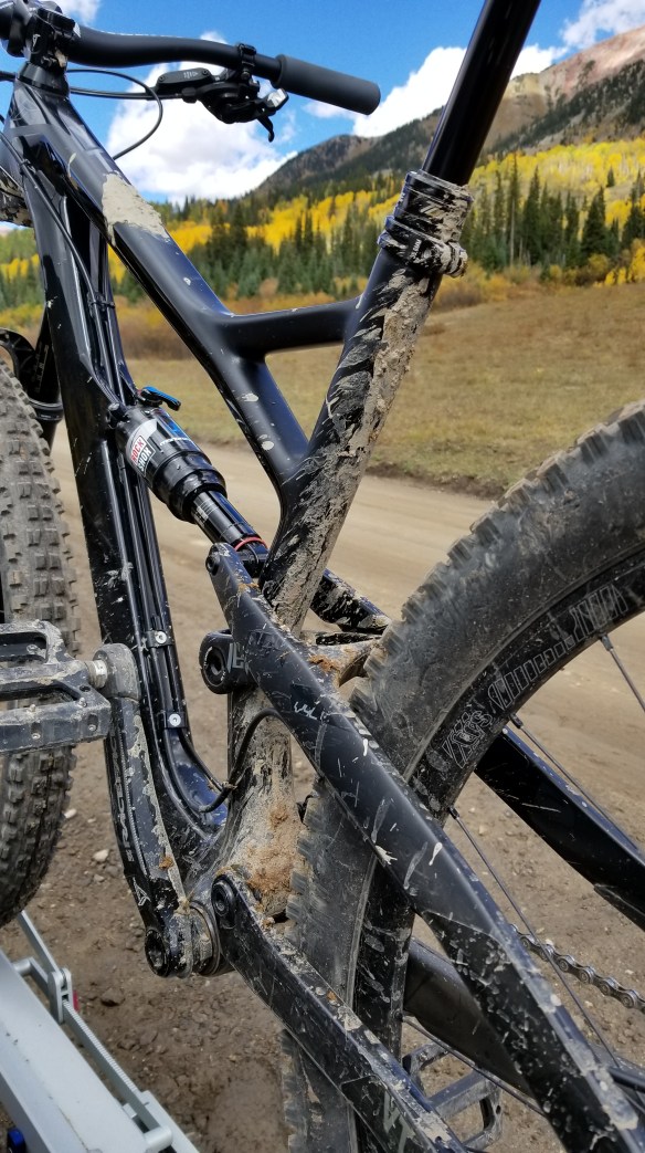
The rest of the downhill was more great cornering practice, with a few more rocks thrown in for good measure. It was over a little too fast, and then it was back to the car park, as the Brits would say. My bike had enough mud splattered on the frame to certify this as a legit mountain bike ride!

20180920_140030

I had that runners high feeling after completing that trail! Yeah, I mountain biked it, I didn’t run, but I never hear people talking about a mountain bikers high. Why is that? Actually, a mountain bikers high is much higher than a runners high. At least for me. Screw running.

Anyway, check out the video, if you will:

#LiveTheAdventure

Perfect Start to the Perfect Week!

It was just after sunset in Crested Butte. I had left a muggy Dallas morning 13 hours prior, and just arrived in the high altitude chill of the Colorado rockies. After getting the car unloaded, I got in a bit of social media time before hitting the sack. I had planned on taking it easy tomorrow, giving my body a chance to acclimate to the elevation before doing any big mountain bike rides.

However, my social media time would reveal that one of my favorite YouTubers, Alex aka The Singletrack Sampler, was going to be riding at Evolution Bike Park in Crested Butte tomorrow! Well, there is a chair lift. I wouldn’t have to climb. So while the elevation would still affect me from muscling the bike on the downhill, it wouldn’t be nearly as bad. I couldn’t pass up the opportunity! I’d been wanting to meet & ride with Alex since I discovered his channel, and the chances of him visiting north Texas to ride our flat XC trails are slim to none!

As far as how that day went, I’ll let the video do most of the talking! I had a blast, and felt as though I learned a few things from Alex, as well as local shredder Dakoda (Taggalong MTB), who has a few KOM’s at the bike park, so needless to say he’s a hell of a rider!

For the second day, I was still figuring I’d take it easy and continue adjusting to the elevation. It takes a good 2-3 days to acclimate, so I wasn’t trying to do any epic rides on day 2! I learned from my mistakes a month ago in Angel Fire!

Strand Hill was the perfect trail. 7.5 miles long, less than 1,000 feet of climbing, and it was only a short drive down a dirt road from where I was staying. I read that it had a fun, flowy descent. I’m in!

I started my morning early with a drive down Kebler Pass. I drove through here two years ago, and it was one of the most beautiful drives ever! I got some drone flying in, but as I got to the spot that had the most color a couple years ago, it appeared it was still too early. There was still a lot of green left. I was still able to find some good shots, though!

No doubt, the highlight of the early morning was getting to see a bull moose! It was on Kebler Pass that I saw one two years ago, but it was a long way down a steep bank on the edge of a creek, and before I could put my telephoto lens on, he had slipped back into the woods.

This time, he was right off the side of the road! I was frantically trying to adjust the settings on my camera to allow a fast shutter speed, while maintaining adequate exposure. The moose was in the woods, so it was only through small openings that I had opportunities for shots. But as luck would have it, there was a gravel road coming up! I repeated, “come out on the road, come out on the road!” The moose obliged!

At one point he was rummaging through the brush next to the creek very close to the road. I could hear twigs snapping, the moose grunting, and I could smell his B.O. It was not much different from that of your common cow. And not that it was a pleasant smell, but it added to the experience! Up close & personal with the King of the Forest!

My goodness, what an amazing creature! So huge, so powerful, and yet so beautiful.

Okay, so onto the bike ride! The climb up to Strand Hill wasn’t too bad, but I still had to dismount and walk several sections. The descent was as good as advertised! Flowy, fast, and fun! A lot of it went through thick aspen groves as well, and up here the leaves were at their peak! It was so beautiful! This, to me, is as good as mountain biking gets!

#LiveTheAdventure

Angel Fire Bike Park

I was going to go last summer, but then I got laid off from my job. I was going to go earlier this summer in June, but then I broke my wrist in April, and was not fully recovered by June. So FINALLY it all worked out for me to visit Angel Fire, NM a couple weeks ago!

I had heard a lot of great things about Angel Fire Bike Park. It’s one of the best bike parks around, even compared to some parks in Colorado. There’s a good variety of trails, and the trails are really fun. It’s also the closest major bike park to Dallas.

Getting there proved to be an adventure in itself! Due to the recent wildfire in Ute Park, Hwy 64 is prone to flooding, and it’s that time of year where afternoon storms are a daily occurrence. I had made it all the way to Cimarron, NM, just about 50 minutes away, when I came up on a road block. Due to the flooding, they shut down the road on a daily basis. I talked to some folks who had already been there waiting for over 2 hours! I waited for about 45 minutes before I decided to take the only logical alternate route I could find, which would add an hour and a half to the drive!

It wasn’t until I was at the point of no return, so to speak, that I found out this route included 9 miles of unpaved road through the mountains! In fact, I didn’t find that out until I was at the point where it turns from paved to unpaved! Mind you, I drive a Honda Accord Sport, which has low-profile tires. It isn’t made for roads like this!

The first half of this road was very rough, with a lot of rocks, but luckily nothing so big that a passenger car can’t handle it. However, because it was so rough, it meant that I had to creep along at 10 mph! Thankfully about halfway into this 9 mile stretch the road became smoother, and I could speed up some. I’ve never been so happy to be back on paved road as I was at the end of this! I didn’t take any pictures or video there, because I just didn’t want to stop!

When I made it through, and just started to enter Angel Fire, I was surprised by two bull elk just off the road to my right! What a treat as I arrived in town!

DSC_5646-2

So when I finally made it to the campground, I had a change of heart. The tent camping area was less than desirable. Nobody else was camping in a tent there; only RV’s. It was cold, windy, and more rain was on the way. I decided I really didn’t want to camp! I got on my phone and found that Angel Fire Resort had a couple rooms left, and Expedia had them at a 15% discount (though it was still significantly more expensive than camping)!

20180816_202248

Sometimes you can’t put a price on comfort. In the end, it was worth it.

Alright, so lets get to the bike park! Since I was at the resort, the park was right there. I got there early to get my pass and sign the waiver. As a result, I was 3rd in line to get on the lift when it opened at 9!

First run I figured I should take Easy Street (green) to warm up, get a good feel for the mountain, the speed, and how my Jeffsy handles it. After that it was time for some more rowdy trails! Ziggy (blue) is right there when you get off the lift, and it’s an absolute blast! Constant left & right flow with some technical chunk thrown in for good measure! I ended up riding it again later on (at a higher speed). Further down, I hit Boulder Dash (blue), which is a jump trail filled with table tops and big berms. I actually wish I would’ve taken this trail again just to work on jumps! The very first jump I thought I overshot, but looking back at the video, I think it was actually perfect! However, because I thought I overshot it, I was checking my speed on a lot of the other jumps, causing me to case them. Coming from the flat lands, it takes some getting used to! Slowly but surely I’ll continue to improve my jumping skills!

On my third run I took Angel’s Plunge (blue), and boy was that a riot! Steep with loose gravel at the top, this trail was FAST, flowing, and fun! I’d say it’s a must ride with any trip to the park!

Other trails I hit included Diesel (blue), Duke (blue), Sierra (green), and Chutes & Ladders (blue). Chutes & Ladders had a lot of wood features. These bridges climbed way up above the surface, and had some super steep drops! I actually skipped a couple of them, since I was riding alone, and they went straight into a sharp turn, and I wasn’t comfortable carrying so much speed into those turns. In hindsight, I probably could’ve done it and been fine. Maybe next time.

After five runs, the lift was closed due to storms in the area, but I was pretty well finished, anyway. Downhill mountain biking exhausts you in a different way than XC riding will. Your legs are fine, because you aren’t pedaling. But the rest of your body seems to take a beating! It actually takes a lot of energy, and a lot of muscle to maneuver the bike around at high speeds, through incredibly bumpy and steep terrain. So if you’ve never done it, don’t expect to be able to just ride all day! You will get tired!

Luckily this time I didn’t develop any blisters, thanks to my wonderful ESI Extra Chunky grips! Seriously love these grips! That “Extra Chunky” part is crucial!

Check out the video! #LiveTheAdventure

That Light, Though!

DSC_0902

One evening of my fall Canada vacation I decided to drive up to the Norquay Ski Area to take some photos at sunset. Little did I know what I was in store for!

There were a lot of clouds at the time, but the breaks in the clouds allowed rays of sunlight to shine through, creating a very dramatic scene in the valley over the Vermillion Lakes. I was so excited I was literally pumping my fist, smiling from ear-to-ear, and yelling, “YES!” I honestly don’t think I’ve ever gotten so pumped up about the photos I was taking! I feel like this looks like something out of a movie! What do you think?

My Best of 2017

DSC_0068

Aqua colored Lake Minnewanka. Golden larches. Snow-capped jagged peaks. Lush green pine forest. I’m not sure it could get much better!

This hike did not end with a summit, but it did end with quite a view! The hike was tough, especially the last mile or so, that seemed to be at a 45° grade. I wasn’t quite used to the elevation yet, so I was huffing and puffing as I made my way up. In spite of cool temperatures, I was still sweating.

The dense pine forest was so peaceful. The climb was so rewarding. The view was out of this world. This was a spectacular moment, and the photo may be my best of 2017.

(C-Level Cirque Trail)

Rugged Wilderness

From now on I’ll be posting short stories around a single photo or video. This will allow for much more content to share! It has been a long time since I last posted, so it’s time to play catch up!

DSC_9989

This shot was taken from Moraine Lake Road after a long first full day in Canada. Somewhere around 14 hours at this point, where I drove all the way up to Jasper. This wasn’t even one of my top 5 shots that I was after that day, but after some editing, it has become one of my favorites!

The sun was just getting ready to set, and I had just seen Moraine Lake for the first time. I was starving, as I hadn’t eaten much that whole day. Some granola bars in the morning, and beef stew with some outstanding bread at Sunwapta Falls in Jasper for a late lunch.

What I love about this scene is that it is the essence of the Canadian Rockies. Raw, rugged, untouched wilderness. A dense pine forest in the foreground, with jagged mountains above, capped with a glacier and a light snow. Speckled among the pines on the upslope of the mountains are some golden larches, not far from losing their needles for the winter.

Ahhhh… I love autumn in the mountains!

9/24/2017

The Top of Texas

I have an idea. Instead of just visiting all 50 states, why not summit the tallest peak in each of the 50 states? Sure, in some cases this is not that exciting, like in my birth state of Indiana, for example. The highest point of Indiana is just a spot you drive to and walk a short distance. Woo. But in the western states, there are actual mountains to climb, and how cool would it be to say I’ve reached the highest point in all 50 states?!

Whether I accomplish that or not, I could at least start with my current home state’s highest peak. That would be Guadalupe Peak located in Guadalupe Mountains National Park. This is actually one of the least visited National Parks in the country, ranking 48/59 in 2016 with 181,839 visitors (for comparison, the #1 park was Great Smoky Mountains with over 11 million!). Given its location, that does make some sense. In the middle of the Permian Basin, oil wells dominate the region, and there are no cities or even large towns nearby. There are no hotels within about an hour of the park, and the campgrounds are small. It’s just not an easy park to visit, especially if you plan on staying for more than a day or two.

For me it was about an 8 hour drive. In order to accomplish this over a weekend, I had to leave immediately following work on Friday evening, drive to Midland (about 5 hours) and stay the night, then get up early (I mean REALLY early; 4 am!) to complete the drive and begin the hike by sunrise. So that is what I did!

Preparation is the key to success. If I were to complete this hike, I’d definitely need plenty of fuel! Take a look at my selection of goodies!

DSC_9129

I started my hike just before 8 am. It’s 4.2 miles from the trailhead to the summit, with a gain in elevation of just over 3,000 feet to reach the summit at 8,749 feet above sea level. This park is known for its wind, so I had watched the weather for a while, and found a weekend with almost no wind. It was also pretty warm, so the long-sleeve shirt and jacket I had with me were not even needed.

Wildlife in this park includes black bears, mountain lions, and mule deer, among others. I didn’t see any bears or mountain lions, but I did run into a few mule deer. Two grown females, and three young ones, probably yearlings.

DSC_9178

They weren’t too sure about me, but they didn’t run away, either. I always love running into wildlife. Such a treat! Love these animals!

The first mile or mile and a half of this trail is the steepest. Good news and bad news, I guess. You certainly don’t ease into the hike, but on the plus side, you get the hardest part out of the way first. It also means the views get pretty spectacular pretty quickly.

You get a little bit of everything on this trail. There is some loose rock, some slick rock, open desert area, and pine forests. In the morning the trail starts in the sun, but then goes into the shade on the western slope, as the trail levels out somewhat. It’s a welcome break after that initial steep ascent in the sun.

Perhaps my recent increased activity level helped, or perhaps it was due in large part to frequent stops to take photos, but this hike ended up being less strenuous than I had anticipated. It took 3 hours and 15 minutes for me to reach the summit from the trailhead. Without all of the breaks, I think if I really pushed it I could do it in around 2 and a half hours.

There’s a big silver pyramid marking the summit, with a lock box containing a register. I signed the register, and took a break to eat a few Kashi bars, drink some water, and take some photos at the summit.

I’m well aware of the fact I’m not making any fashion statements with that outfit! But that was the only moisture-wicking shirt I had, and the shorts are actually convertible pants, which are very convenient when you’re not sure what the temperatures are going to be like.

Going up is your cardio workout, and coming back down is without a doubt your leg workout! My quads were burning by the last mile, and of course that would be the steepest part! It’s almost easier to jog down. I did not take any breaks on the way down, and it only took an hour and a half!

At that point I took the opportunity to get my entrance sign selfie, and then decided to head up to Carlsbad Caverns (about 45 minutes north).

I had originally planned on camping at the park and going to Carlsbad Caverns in the morning, but the campground was full. As it turned out, that was a very bad time to visit Carlsbad Caverns. It was absolutely packed, and I just didn’t have time to go through it all, so I was in and out, and did not see the most interesting sections. Oh well. I had to get to the next spot that I wanted to photograph, which was the salt flats! But first, I had to stop and get the iconic shot of El Capitan!

DSC_0021-HDR-Edit

Then it was off to the salt flats. I assumed it was okay to drive on them. There were no signs to tell me otherwise! There were also plenty of tire tracks, so out onto the flats I went. Pretty cool place!

DSC_0038

That would be a really great spot to shoot the sunrise. Maybe some other time. After that I made the drive to Prada Marfa. It is located in the middle of nowhere on US-90 in southwest Texas. No, it’s not an actual Prada store. It’s a sculpture by artists Elmgreen and Dragset. It’s not even in Marfa, it’s in Valentine. Marfa is another 26 miles to the southeast.

It originally contained actual Prada shoes and purses, but was vandalized 6 days after it was completed, and those items were stolen. They were then replaced with knock-offs.

DSC_0083

Since my camping plans were spoiled, I then decided to drive all the way to Odessa to stay in a hotel room for the night. I was completely exhausted by the time I got there, but it left me with just a little over a 5 hour drive on Sunday to get back home. So it was really a one-day adventure, lasting about 20 hours! Carpe diem!

Here is a vlog I put together on my hike to Guadalupe Peak. In the future I plan on either getting a dedicated camera for this, or at least a gimbal to stabilize the phone shots.