I first rode Brown County State Park in Nashville, IN (not a typo, it’s INDIANA!) when I was still a new rider in the summer of 2017. It is still to this day my longest ride ever at 32 miles! Shortly after that ride, they opened a new flow trail, Hobbs Hollow. Now there’s yet another new trail open, Weed Patch.
I was back in Indiana in the spring of 2018 for a friend’s wedding, but that was shortly after I had broken my wrist in Moab, so I was unable to ride. In the spring of this year I was back for another friend’s wedding, but this time excessive amounts of rain had all of the trails closed!
Thankfully, luck would be ON my side for this trip! I was back home for Thanksgiving, and Mother Nature blessed me with a 57° day! While it had rained a couple days prior, the trails had enough time to dry up and be just fine for riding (minus some mud puddles here and there).
The new trails were absolutely fantastic! I rode Weed Patch in both directions in order to sample both downhills, and it’s great in either direction. Reminded me so much of the trails in Arkansas! They didn’t just build the downhill sections to go straight downhill. There were a lot of little rollers that allow you to keep momentum going back up a little bit so that all the elevation isn’t used up in a quarter mile! And that’s exactly how they’ve been building trails in Arkansas.
The terrain is pretty similar, too. They aren’t big mountains with a lot of elevation change, but they are rolling hills with a few hundred feet of elevation to work with.
Hobbs Hollow did not disappoint either! There are a lot more jumps on Hobbs Hollow, but unfortunately the lips on these jumps were not very well-defined. They were rounded off a bit, but that’s to be expected this late in the year. I’m sure that come springtime the trail crew will be out there re-working those lips, and I can’t even imagine how great it’ll be then!
Of course, I’m also not that great at jumping anyway, so even if the lips had been freshly packed, I’m not sure I would have been clearing those table tops. They seemed pretty long given the speed… okay, maybe I’m too slow, too!
All in all, it was a fantastic day in the woods! Glad that I finally had the opportunity! Check out the video below!
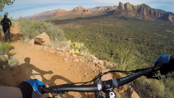
Back in the spring of 2016, I took a road trip through Arizona, from Tuscon all the way up to Page. That included a one day stop in Sedona. I didn’t even stay one night there, but in that single morning & afternoon, I packed quite a bit in! I hiked around Bell Rock, out to Devil’s Bridge, visited the Airport Vortex, and found the Secret Slickrock for a view of Cathedral Rock just before sunset. Oh yeah, and I saw a pretty good sunset out there!
I absolutely loved Sedona, and I knew I’d be back. That was before I was even into mountain biking. After gaining this new passion, I learned that Sedona was one of the premier destinations in the country for mountain biking! Fast forward to now, and I made my return to Sedona to ride one of the world famous trails.
It would only be for one day, once again, unfortunately. Time is money, and I don’t have a ton to spend! Thanks to my YouTube channel, I had a whole group of guys to ride Hiline with, as it’s not really a trail I think I’d want to take on by myself. Well, okay, I could have done it alone, but I probably would’ve walked even more sections than I did.
The trail begins with a tough, technical climb up. Having been off the bike for so long, my technical climbing skills have definitely regressed. Nonetheless, I gave it a good effort! Next up is the exposure. This section of the trail is on the edge of a cliff, although it’s not nearly the death-defying experience that is Portal Trail in Moab! The cliff isn’t as high up & isn’t so straight down, the trail is wider, and there’s a lot more brush that would likely (hopefully) catch you before you tumbled all the way down the hill. Still, I wouldn’t want to fall to the right and test any of that out!
There are great views along the way, but most of your focus has to remain on the trail. Some parts get a bit techy, but it’s all doable. Get to the top and you’re rewarded with a great view in every direction before dropping into the descent.
The descent starts with some janky rocks that also give some exposure, then smooths out into a fast & flowy section through the junipers. You come out onto the slickrock, and are greeted by some steep rollers, some of which are optional lines, and a steep & rocky chute, that would end up ejecting me from my bike!
It’s my own fault. I should have first taken the time to look more carefully at the line at the bottom of this chute, as well as slowed down some. But most of all, I shouldn’t have had my weight so far back. Yes, you can have your weight too far back. As I went frame-by-frame through my video (3rd person shot by Chris, thanks man!), I realized I had too much weight on the back wheel, which caused it to buck me off the bike. In fact, at one point I may have even “sat down” on the rear wheel, which led to the buck off.
No worries for me, as I came up with nary a scratch, but my gimbal didn’t take it so well. Both of the arms were bent, causing the gimbal to lose its range of motion by contacting itself, throwing everything off. I found a different mounting position that eliminated this issue, however, the arm of the gimbal partially obstructed the view of the GoPro with this orientation. Rats! The rest of my video would feature the juncture of the two gimbal arms in the upper-right portion of the frame! Luckily I found a better solution for the following day… just flip it the other way around.
Anyway, the trail had some more steep technical sections after that. I really wanted to try these, but after that crash I decided not to push my luck. Video can never do these sections justice, as the camera tends to flatten things out and make them look smaller than they really are. This stuff was steep, and looked like an OTB waiting to happen! Next time I’ll try it, I swear!
I would end up with one more crash on a slickrock section, where I simply slid out. Wasn’t even that bad of a crash, but I slammed my left hand onto the rock, and it was bruised pretty good. I initially hoped I hadn’t broken it, as it hurt in the same spot as my right hand did when I broke my trapezium last April in Moab. However, the pain just felt different, and luckily by the following morning it was already feeling better.
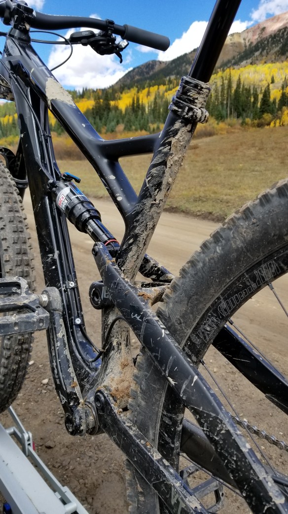
At some point along the way, I also bent my derailleur hanger, though this may have even happened on the day before on National Trail. I suspect that, as I was having problems prior to either crash with shifting. The chain was coming off the large cog and getting lodged between the cassette & spokes on several occasions. Prior to this trip, everything had been dialed on this bike, so I knew something was up! I already had a spare, so I’ve now replaced that, and it’s flawless again!
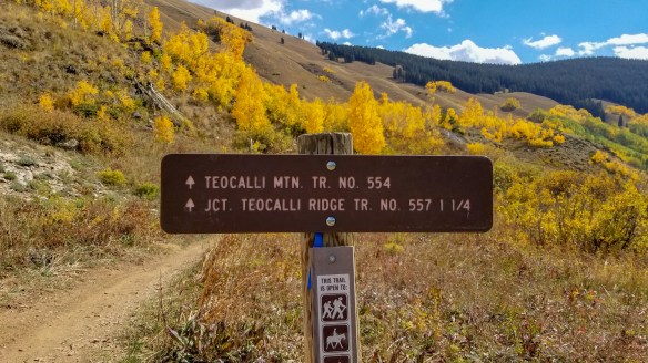
I could not ride for 6 days in Crested Butte and not hit Trail 401! It always comes up whenever I read an article about mountain biking in Crested Butte. I considered it a must for this trip!
Trail 401 is a bit longer in distance than Teocalli Ridge, but the elevation gain is about the same. The difference is that it’s split into two climbs on Trail 401. I knew it’d be another tough climb, regardless. I live in flat lands 500 or so feet above sea level, so being over 11,000 feet at the peak of these trails after climbing roughly 2,000 feet was going to be difficult no matter what!
It’s a little over 6.5 miles from the parking area to the start of the downhill, and most of it is on the road. This road climb wasn’t too bad. I was actually able to pedal the majority of it. At one point I passed a couple who were driving up the road and stopping to take in views along the way. The guy asked me, “is that fun?” I replied, “Not yet!”
Even if it was just a workout at this point, the views were spectacular. I think that’s really the case no matter what trail you ride in Crested Butte!
Once you enter the singletrack, it really starts to go up. I had to walk a lot on this section. After venturing into the forest, with the wind picking up, and my body drenched in sweat from all the exertion, I started to get quite chilly! I’d take my jacket off to try to dry up some of the sweat, but I really needed the jacket on to cut that chilly breeze. I was also a little paranoid. It was very quiet. I was all alone. There are bears and mountain lions in this area. My head was on a swivel. Suddenly, my heart skipped a few beats as I heard a loud cracking & crashing, ending with a low-pitched thud! A tree had fallen nearby! I didn’t see it, but it couldn’t have been too far away. As if I wasn’t paranoid enough about animals that could eat me, now I had to worry about trees falling on me!
Needless to say, despite my gasping for oxygen-depleted air, and rubber-like thighs, I continued to pedal as much of this singletrack as I could. At this point I was getting mad at the fact this climb wasn’t over yet! But a little anger is always a good thing when you need to push yourself physically!
There was no rain in the forecast on this day, but as I approached the top, there was clearly rain off to my west. I better hurry up, I thought. I wasn’t too worried about it once I got going downhill, as I’d be going fast, and I’d be moving away from the dark clouds. Luckily I was soon starting the descent, and I never looked back.
The descent starts on a lot of straight trail, but it’s fast, and has some great views of the valley! In the summer, this part of the trail is lined with wildflowers, but in the autumn they have all turned brown and lost their will to stand up straight.
After kindly asking a couple cows to remove themselves from the trail, I got into a bit more flowy section with loamy hero dirt! I was really working on my cornering all week, focusing on leaning the bike, while keeping my torso upright and fighting the urge to squeeze the brake levers. I felt really good out there on Trail 401! The primo dirt conditions certainly didn’t hurt matters.
I made it down the initial downhill in a hurry! As a matter of fact, close to the top 10% on Strava! Well, I’m sure most people stop a million times to take in the views and snap a few photos, so take that with a grain of salt. Though I do think at this point in the week I had already gotten faster than I was on day 1.
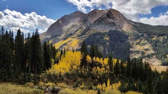
On the second climb I came across one of the most beautiful landscapes I’ve seen looking over toward Gothic Mountain. Goodness! Just look at it!
Do you smell that? Oh wait, I can’t send smell through blogs. Dang it! I really wish I could. The wonderful aroma of the pine forest is one of my favorite scents! You won’t hear this from many people, but… I must say, Trail 401 smells great!
The rest of the downhill was more great cornering practice, with a few more rocks thrown in for good measure. It was over a little too fast, and then it was back to the car park, as the Brits would say. My bike had enough mud splattered on the frame to certify this as a legit mountain bike ride!
I had that runners high feeling after completing that trail! Yeah, I mountain biked it, I didn’t run, but I never hear people talking about a mountain bikers high. Why is that? Actually, a mountain bikers high is much higher than a runners high. At least for me. Screw running.
What can I say about Teocalli Ridge? It’s downright awesome! Okay, let’s start from the bottom.
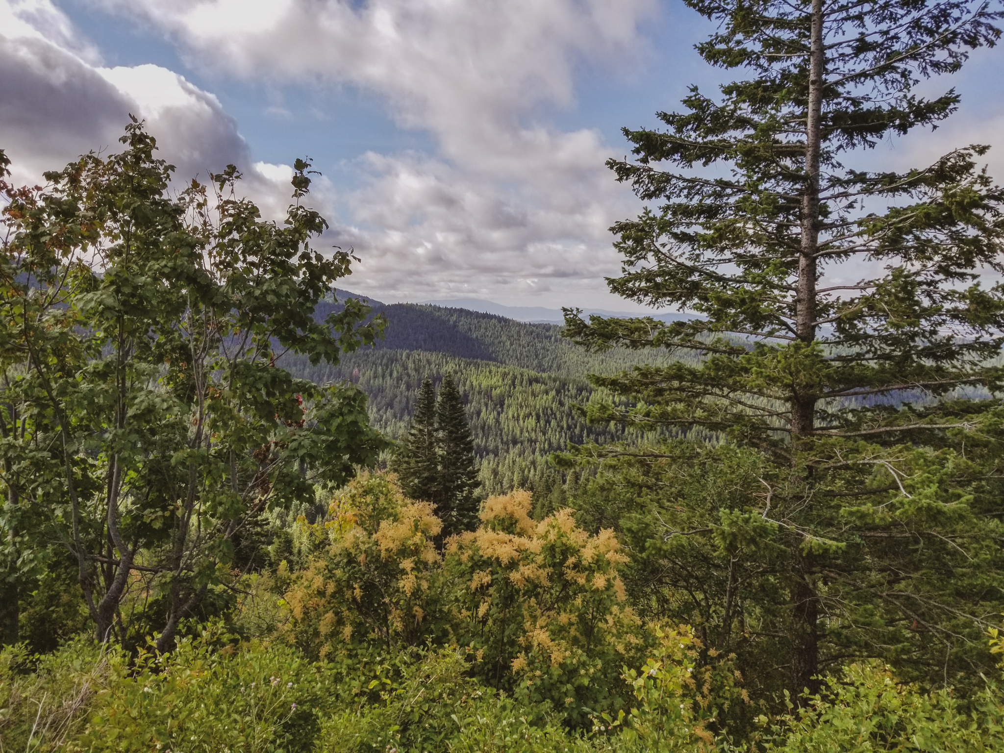
After a brief steep climb, it levels out for quite a while. It remains pretty mellow the whole time you’re on the road. If you’ve got a couple of 4×4’s, you could shuttle this road section, but it’s not that bad to pedal. The best part is that you’ve got killer views the whole way, especially in the fall! It is so pretty out there!
Once you get on the singletrack, however, the grade instantly gets steeper! I was walking a lot, but I had no qualms about doing so. I had already decided on this trip that I’d be taking my sweet time on the climbs, since I had all day anyway! I wanted to save my energy for the downhill!
There wasn’t any rain in the forecast, but at one point on ominous cloud was coming over the mountains, and I thought I might be in trouble! I got a few sprinkles up near the top, but that was it.
When you think you’re at the top, you’re not. There’s a short downhill section, then it’s back to climbing again. It isn’t until you’ve arrived at the overlook that the real downhill begins.
And my, oh my, how great is the downhill?! 6 miles and about 2,000 feet of descending through rooty, rocky bits at the top, flowy forest in the middle, and switchback city through the aspens near the bottom, finishing it off with more flow through a sagebrush-filled meadow at the end. With perfect temperatures and beautiful bright yellow aspen leaves everywhere, seriously, what more could you ask for?!
The combination of all of that makes this my new favorite trail. Outstanding scenery, and probably the most fun descent I’ve ever ridden. It took me a total of nearly 3.5 hours to complete this ride, but I’d do it again in a heartbeat! If you’re in Crested Butte to ride your bike, this trail is a MUST!
Unfortunately the bike shop didn’t open until 10 AM, so it was 11:30 AM or so before I got up to the trailhead. That meant the sun was up high, and it was pretty hot. Yeah, it’s a dry heat, which is wayyyyy better than Texas, but it was still in the 90’s that day. Would make for a sweaty climb.
I parked at the lot where Trail 290 ends, and climbed up the road. It seemed like a tough climb while it was happening, but once I reached the top I looked back on it and thought, hey, that wasn’t that bad! It’s only roughly 1,500 feet, and took me about 45 minutes. Plus it included some good views along the way!
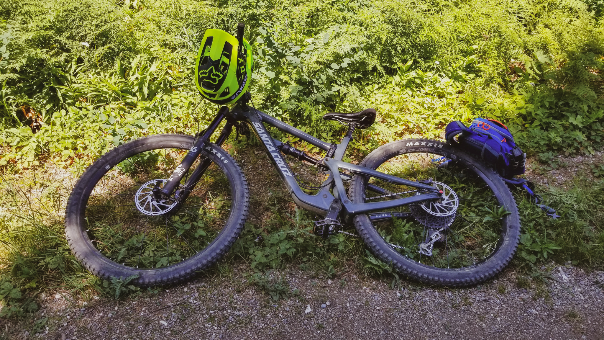
The trail was sweet! Totally different type of riding than what I’m used to. I mean other than it being downhill, of course. It was pretty flowy, but also had some ruts, roots, and a few rocks. In parts it was really steep! It required a lot of mustard, as I put it. I guess “body English” would be a more understandable term for the masses, but I think mustard sounds more intriguing. The Santa Cruz handled it well!
At one point I stopped to get a good selfie for my YouTube banner photo. Yep, I had lugged my 3.5 pound camera + lens up that climb! I used my Gorilla Pod to set it up on top of a branch, put the camera on continuous shooting every 0.5 seconds for like 100 photos, rode back up the hill, quickly turned around, and rode back down! Wooo!
I was concerned about how it would turn out with such harsh light amongst the shadows, but with some editing it looks pretty good! Love the dynamic range of that Nikon D500!
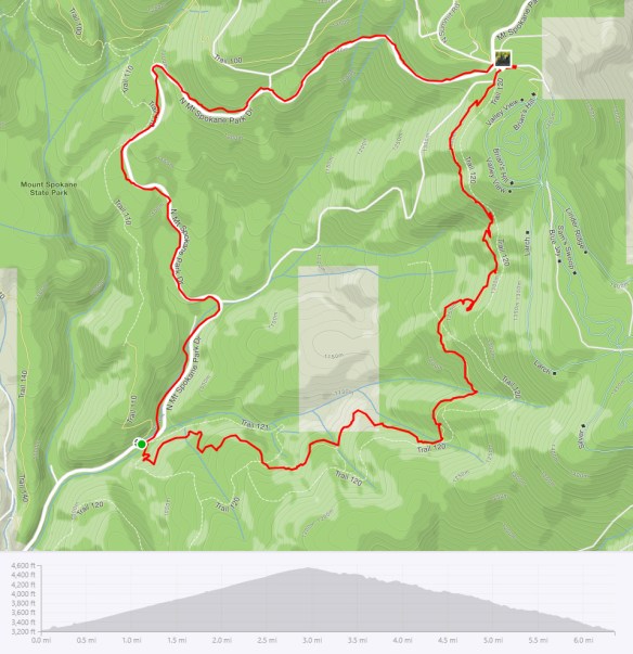
Here’s a look at the map of my route, and the elevation profile from Strava (click it to view the activity on Strava):
Heck, it wouldn’t even be that bad to ride that twice! I think most people shuttle the rides here, though, and would ride Trail 290 and Trail 140 (video & blog coming up next week!) on the same day. I didn’t have a shuttle, so I didn’t do that.
Anyway, the video is below, so enjoy! #LiveTheAdventure